“Unfold a map of North America,” Keith Heyer Meldahl writes, “and the first thing to grab your eye is the bold shift between the Great Plains and the Rocky Mountains.” In this absorbing book, Meldahl takes readers on a 1000-mile-long field trip back through more than 100 million years of deep time to explore America’s most spectacular and scientifically intriguing landscapes. He places us on the outcrops, rock hammer in hand, to examine the evidence for how these rough-hewn lands came to be. We see California and its gold assembled from pieces of old ocean floor and the relentless movements of the Earth’s tectonic plates. We witness the birth of the Rockies. And we investigate the violent earthquakes that continue to shape the region today. Into the West’s geologic story, Meldahl also weaves its human history. As we follow the adventures of John C. Frémont, Mark Twain, the Donner party, and other historic characters, we learn how geologic forces have shaped human experience in the past and how they direct the fate of the West today.
I read a book about geology like it is a book about spirituality. Deep time, the illusion of permanence, the movement of the landscape I worship, learning intricately of the earth upon which we walk and play and dance and rest and celebrate and weep upon: this is the simplest wonder of the world that never, ever fails to make me believe in the breadth and depth of our human experience and yes, our spirit. I know I won’t be here 15 millions years in the future, nor 1 million, nor 500 nor, even, 100 years. And sometimes, yes, that is staggering and very sad, because I want to, it seems imperative that I see these changes. And other times, I just have this deepest, truest feeling that it doesn’t matter, that somehow it is alright, anyways. Somehow I think I will know or see, somehow. John McPhee in Annals of a Former World started this wonder; and Keith Meldahl feeds it and abundantly so. I like that Meldahl is a geologist, it does provide a different lens that McPhee who was a layperson deciphering the world of rocks and time. To walk, drive, hike through the world knowing which hill is from the Cenozoic, an unconformity that is special for what time periods, say billions of years, are missing, or which mountain top was formed under the ocean or on a floodplain or desert sand dunes is to know such beauty. This geologist has a great sense of humor too: a model for California with beer cans complements the sometimes dryness of text extremely well. From the imagery of touching the edge of a continental plate or touching a rock outcrop to span millions of years of history, he is tactile, and experiential, and makes geology a vibrant, felt sensation.
“Mountains are the rest of the body of the earth, what violent muscular action is to the body of man. The muscles and tendons of its anatomy are, in the mountain, brought out with force and convulsive energy, full of expression, passion, and strength.” John Ruskin, 1848
…viewing the Earth through the lens of human time…gives the illusion of stability to a world that, over geologic time, is radically mobile…to know that the Atlantic Ocean is forty-three feet wider today than when Columbus crossed it lifts, just a little, the veil of our illusion.
It is mind-bendingly strange to see the roots of pines wedged into serpentinite-rock that once lay five miles below pillow basalts that once lay three miles below whitecaps that once billowed hundreds of miles west of where California didn’t yet exist.
Plants aren’t the only thing to change as you go up or down a mountain. The nature of raindrops changes as well. Ancient raindrops contain a chemical signal that can tell us the elevation at which the rain fell. Here’s the idea: the hydrogen in water molecules comes in one of two forms, or isotopes; a lighter form and a heavier form. The difference means that individual water molecules differ slightly in weight depending on whether they contain heavy or light hydrogen. As moist wind rises up the mountain, the air expands and cools, dropping its moisture as rain or snow. Heavier water molecules tend to fall first. As the air continues up the mountain, the clouds are progressively depleted of heavier water and drop a greater fraction of lighter water. If you then compare what you find in present-day raindrops to ancient raindrops, you can tell roughly the elevation at which the ancient raindrops fell.
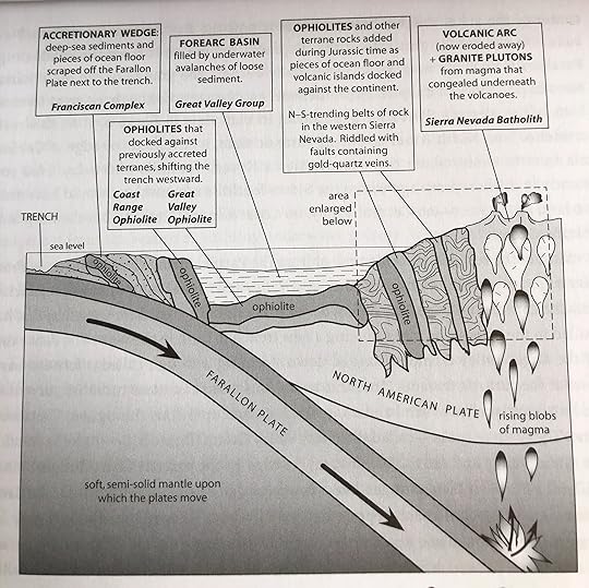
When oceanic plates subduct, they take quadrillions of tons of old seawater down with them into the mantle. (The seawater is trapped in the hydrated minerals of serpentinite below the oceanic crust, as well as in the mud of the seabed and in fractures in the crust.) Once a subducting plate reaches a depth of about eighty miles, the intensifying heat drives this trapped seawater out of the plate into the surrounding mantle. Water has a curious effect on hot mantle rock-it lowers its melting point. Catalyzed by water, the hot mantle just above the subducting oceanic plate begins to melt. This magma is the start of granite.
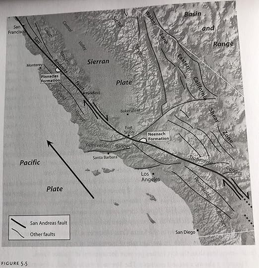
Each scenario is about fifteen million years into the future, and each assumes that the Pacific Plate will continue to move northwest at about 2.0 inches per year relative to the interior of North America. In scenario 1, the San Andreas fault is the sole locus of motion. Baja California and coastal California shear away from the rest of the continent to form a long, skinny island. A short ferry ride across the San Andreas Strait connects LA to San Francisco. In scenario 2, all of California west of the Sierra Nevada, together with Baja California, shears away to the northwest. The Gulf of California becomes the Reno Sea, which divides California from Nevada. The scene is reminiscent of how the Arabian Peninsula split from Africa to open the Red Sea some 5 million years ago. In scenario 3, central Nevada splits open through the middle of the Basin and Range province. The widening Gulf of Nevada divides the continent form a large island composed of Washington, Oregon, California, Baja California, and western Nevada. The scene is akin to Madagascar’s origin when it split form eastern Africa to open the Mozambique Channel.
Colorado and Wyoming are America’s highest states, averaging 6,800 feet and 6,700 feet above sea level. Utah comes in third at 6,100 feet, New Mexico, Nevada, and Idaho each break 5,000 feet, and the rest of the field is hardly worth mentioning. At 3,400 feet, Montana is only half as high as Colorado, and Alaska, despite having the highest peaks, is even further down the list at 1,900 feet. Colorado has more fourteeners than all the other U.S. states combined, and more than all of Canada too. Colorado’s lowest point (3,315 feet along the Kansas border) is higher than the highest point in twenty other states. Rivers begin here and flow away to all the points of the compass. Colorado receives no rivers from another state (unless you count the Green River’s brief in and out from Utah). Wyoming’s Wind River Range is the only mountain in North America that supplies water to all three master streams of the American West: Missouri, Colorado, and Columbia rivers.
Interstate 70 arrows through Denver and plunges into the Front Range through the Dakota Hogback- a spectacular ridge of Mesozoic layers upended by the rising basement core of the range. The highway begins winding uphill through steep-walled canyons that glitter with dark schist, 1.8 billion years old. This basement rock speaks of a time when Colorado looked much like Indonesia: a collection of scattered archipelagoes divided by areas of deep ocean floor. The schist is the squeezed and distorted remains of sand, mud, and lava flows that sloped off the flanks of these islands into the sea. Eventually, the trenches between the islands closed, the islands bunched together to assemble this part of the North American continent.
From the summit of Mount Evans, half of Colorado spreads before you to the east. The barren granite slopes plummet to tree line more than 3,000 feet below. There, in the trees, at roughly 8,000 feet, the landscape flattens into an undulating, forested plateau- the Rocky Mountain sub summit surface. Five million years ago, this sub-summit surface merges seamlessly with the surface of the Great Plains. Now it sails off into open space above a cavernous bowl filled with Denver… To excavate that bowl-the Colorado Piedmont- the South Platte River and its tributaries had to dig out come 2,000 cubic miles of gravel during the last five million years. That’s considerably more than the volume of the Grand Canyon, which the Colorado River cut during roughly the same time span.
Earth processes that seem trivially slow in human time can accomplish stunning work in geologic time. Let the Colorado River erode its bed by 1/100th of an inch each year (about the thickness of one of your fingernails.) Multiply it by six million years, and you’ve carved the Grand Canyon. Take the creeping pace of which the continents move (about two inches per year on average, or roughly as fast as your fingernails grow). Stretch that over thirty million years, and a continent will travel nearly 1,000 miles. Stretch that over a few billions years, and continents will have time to wander from the tropics to the poles and back, crunching together to assemble super-continents, break apart into new configurations- and do all of that again several times over. Deep time, it could be said, is Nature’s way of giving the Earth room for its history. The recognition of deep time might be geology’s paramount contribution to human knowledge.
Push up some mountains. Cut them down. Drown the land under the sea. Push up some more mountains. Cut them down. Push up a third set of mountains, and let the river cut through them. “Unconformity” is the geologic term for an old, eroded land surface buried under younger rock layers. Put your outspread hand over the Carlin Canyon, Nevada unconformity and your fingers span roughly forty million years- the time that it took to bevel down the first set of mountains and deposit the younger layers on top. What is forty million years? Enough time for a small predatory dinosaur to evolve into a bird. Enough time for a four-legged, deer-like mammal to evolve into a whale. And far more than enough time to turn an ape-like creature in eastern Africa into a big-brained biped who can marvel at such things. The Grand Canyon’s Great Unconformity divides 1.7 billion-year-old rock from 550 million-year-old rock, a gap of more than one billion years. One billion years. I earn my salary studying the Earth and teaching its history, but I admit utter helplessness in comprehending such a span. A billion pages like those of this book would stack up more than forty miles. I had lived one bullion seconds a few days before my thirty-second birthday. A tape measure one billion inches long would stretch two-thirds of the way around the Earth. Such analogies hint at what deep time means- but they don’t get us there. “The human mind may not have evolved enough to be able to comprehend deep time, “John McPhee once observed, “it may only be able to measure it.”
My son, having some inkling of my fascination with geology (even though my more obvious loves are music and poetry) got me this book for Christmas. I read it straight through in a day. Meldahl tells a gripping story in elegant, conversational, extremely informative prose, illustrated with numerous photographs, charts, and diagrams. He takes us on a journey from the San Francisco Bay area to the eastern slopes of the Rockies, roughly following interstate 80, stopping along the way to examine the evidence of tectonic forces that shaped the western part of the continent. He shows us again and again that “Geology is stranger than fiction—and more interesting.” Up in the Sierras, he reflects how “mind-bendingly strange [it is] to see the roots of pines wedged into serpentinite—rock that once lay five miles below pillow basalts that once lay three miles below whitecaps that once billowed hundreds of miles west of where California didn’t yet exist.” Or, considering the far western and far eastern edges of the massive North American continental plate, he writes “Electricity, home heating, and hot water: Icelanders get them all practically free from geothermal heat. It’s one of the benefits of living on the edge—the plate edge, that is … Californians, like Icelanders, also live along a plate edge. Unlike Icelanders, Californians reap few benefits from the association—other than the thrill of knowing that death from an earthquake could come any day, which naturally makes each latte and yoga lesson more meaningful.”
The processes of geology play themselves out over a vast time scale, and geologists seem to have developed a very poetic and allusive way of describing those processes: the subduction of ocean plates, the accretion of terranes at continental edges, the solidification of magma into plutons that rise from the depths and join together to form batholiths. Observe Meldahl’s poetry in a passage like this one: “The plutons heated underground waters, which swept up metals and silica from the plutons and the surrounding crust. Pregnant with metals, the waters rose buoyantly along permeable pathways, favoring fault zones above and around the plutons. In these fault zones, the hot waters cooled and dumped their metallic loads as metallic lodes. Thus was seeded the first wave of Great Basin ore—and, to the west, the gold of California’s Mother Lode.”
Meldahl frequently brings us back to the very human encounters with the Western landscape, from the Forty-Niners heading to California in search of gold, to the doomed Donner party, struggling vainly to get across the Sierra Nevadas before early snows stopped them, to the early explorers and scientists trying to make sense of the strange things they found in the Basin and Range province, such as rivers that seem to have punched their way through solid mountain ridges. They wondered what happened to waters that drained the western slopes of the Rockies. Surely they ended up the Pacific? Cartographers imagined a river called the Buenaventura. “In the early nineteenth-century, [the desert region where Nevada and Utah are today] formed a vast, unknown space that maps labeled ‘Unexplored Country’ or ‘Terra Incognita.’ The Buenaventura [River] flowed across this space, in black ink that welled up from the headwaters of simple logic. The Rockies are high and snowy. Rivers begin there. Rivers flow downhill to the sea. Rivers may pause for a time in depressions to make lakes, but they soon flow out the low end of those depressions and continue toward the sea. At least one major river, and probably several, must flow west from the Rockies to the California coast. How could it be otherwise?”
Again and again, Meldahl puts us in the minds of the people asking such big questions about the history of the earth and its landforms, helps us sympathize with their attempts at explanation, and guides us to contemplate the possible theories ourselves, as if we were participating in the development of scientific consensus. We get caught up in the excitement of discovery. This is one of the most enjoyable, clearest books on science I have read.
I loved so much about this book - I'd give it six stars if I could! Not sure I'll be able to stop my fangirling long enough to write anything insightful here, but I guess I'll try.
After reading that really great book on Oregon's ancient geology last year (In Search of Ancient Oregon: A Geological and Natural History), I was inspired to read more more more! More about the places that I've lived and visited extensively here in the Western U.S. This book delivered beyond my expectations, helping me make sense of so many things I've seen while also introducing me so many new geological concepts. Not only were all the delicious tidbits explained clearly (frequently with a touch of humor) but they were served up with incredibly helpful illustrations. It was really the combination of clear writing and informative figures that pushed this into six-star range for me.
I'd have to reproduce half the book if I wanted to talk about all my favorite parts, so here are a few tippy-top highlights.
- First learned about terranes in the Oregon book - but this one included figures so now I can visualize and really understand the process for how bits of ocean plates and such get jammed up on the edge of a continent.
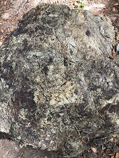
-I was first introduced to serpentinite when I visited the Tablelands in Gros Morne National Park in Newfoundland a few years ago. After that trip, I noticed there's a serpentinite rock on my campus and my mind boggled at them lugging something like that all the way from the other coast. Of course, now I know we have our own sources of serpentinite rock from ocean floors accreted on to California!
-I knew people came to California for gold, but I never really understood how the gold got there or even what hard rock mining was until it was explained here. Blew my mind that there was a court case in 1884 that ended a specific form of mining (hydraulic) in the Sierras - I mean, how bad must it have been to be banned in 1884???
-There is a whole separate plate here in the Central Valley of California that I live on - the Sierran Plate (it's a section of plate that does not move with either the Pacific Plate or the North American Plate). Another mind blown moment. By all means, be like my friend who's already tried to argue with me that I'm wrong but I'll just suggest you try reading the book.
-I need every single dystopian/sci-fi author and lame pundit to study figure 5.7 on page 74. Sigh. California isn't going to sink into the ocean eventually, but there are various scenarios for how much of it is going to get sheared off and head to the northwest with the Pacific Plate.
There's a plenty more juicy bits included but I'm going to stop here. I encourage all my local peeps to read it. Plenty of versions available at the library!
Love this for Cali resident geeks. Geologic time is so humbling-- even a spectacular human achievement is near meaningless on this scale. But the idea small steady changes, an inch or two a year can move continents over time is so encouraging for habit forming.
This is an author who brilliantly tells the intriguing story of Western USA geography complimented by the history of the people. You learn not only how the Sierras, California, and Nevada are formed but also the story of the gold rush 49ers and tragic tale of Donner Pass. For every incredible insight into the geology of the land we learn the implications for those who explore or inhabit its terrain.
John Wesley Powell and his team of explorers are tracked defying death in the whitewater rapids of the rivers that carve canyons thousands of feet deep in the Rockies. In turn we discover how rivers preceded 14,000 foot mountains and sculpted the majestic canyons and peaks that awe our senses. The academic mixes seamlessly with the history to teach with grace. I really would have enjoyed Professor Meldahl’s classroom as a student if it is anything like the experience he creates for the reader.
Rough-Hewn Land is a worthy successor to one of my favorite geology books, John McPhee's Annals of the Former World McPhee tells the story of plate tectonics and how it came to revolutionize the science and explain the world, Meldahl picks up from there and tells us more about the mysteries that we continue to find - and try to explain. The writing isn't quite as flawless, there are fewer direct stories from multiple geologists, but it flows well and makes the story of rocks fun (well, at least to me).
It's a book I looked forward to picking up every night and was sad when I finished, something that usually only happens with good fiction.
An excellent accessible explanation of complex geology of the western fourth of North America over the last several hundred million years. "Beer-can" terranes - brilliant! I found it to be a real page-turner on par with John McPhee's "Assembling California." Incidentally, the subject of that book, Eldridge Moores, gave his endorsement to "Rough-Hewn Land" on the back cover.
I love geology and tried to read John McPhee's book on 'Assembling California'. Too tough of a read for my brain. I tried this book instead and found a wonderful, but very slow read. It took me 8 months with writing lots of notes in the margins. The author explains geology in everyday terms and wove the westward movement into the book and how the early pioneers chose routes to travel on not to travel due to, geology. Land formations! So far I understand the geology of California and now I am branching out to other places. Rocks, rocks and more rocks! How did they get there? What minerals are they made of? Don't get me started, I can bore you very quickly! My backyard pathways are lined with rocks we have collected on our hikes. I especially LOVE 'pennant rocks' from the Sierra Nevada. The are the ancient seabed metamorphic rocks that are banded with many layers of striped rocks.
For those interested in anything related to the geology of the American West, a helpful guide and explainer.
Whereas John McPhee wrote compellingly and well regarding the geology of America, he generally did so in the framework of stories of individuals, and the story of the geology itself was often challenging to follow.
Meldahl goes over the same territory - quite literally, also using Interstate 80 as his guide - but provides more thoroughgoing explanations and a lot of charts which allows the reader to be able to more easily "see" and understand how the various processes came to be which led to the formation of the West Coast, the stretching out of the Great Basin, and the uncovering of the Rocky Mountains.
A great way to better appreciate all of the processes by which the American West has come to be.
Very well done. If you have an interest in geology, appreciate the vast spectacle of the American west, and want to understand how this varied landscape came about, this is the book to read. I would have to call this a text book, but a text book like you've never seen before. It describes plate tectonics and geologic processes in an easily understandable manner, is entertaining, and relates exploration of the west and westward migration to the various land features. This is how all textbooks should be -- almost like reading a novel.
This book is very well written and packed full of interesting geological facts and figures. The information is up-to-date and accurate, and the author allows his personal experiences and his sense of humor to play an important part. This is the first book that I have ever read twice in succession, I didn't want to miss a single item.
I recently moved to the basin and range country and was looking for a book on the geology of the region. This book is the best book on geology I have ever read. It has excellent maps, diagrams and pictures accompanying a very readable and understandable description of the region and the geological forces that gave rise to the basin and range country. I can’t recommend it more highly.
Excellent book. Geologic descriptions that are well-written at a level that most people can understand. Contains a wide range of geologic settings and much detail, but all presented in an interesting and enjoyable manner. Highly educational even for professional geologists (I've spoken with three who have read the book). An absolute 5-rating for this book.
For any other amateur geologists out there who are always wondering why any given mountain range in the American west is there, this is the book for you. Such an concise, comprehensible, and well written explanation of the incredible history of our continent.
It is better than a five star book. Geology professors, everywhere, should consider using this book as a textbook in Physical, Historical, and Structural Geology classes. Certainly the best geology book I have read.
One of the best geology books I’ve ever read. Provides a great explanation of the geology of the western United States, including the reasons behind the Laramide orogeny.
I sipped one section at a time and delved into places presented in each section. I did learn new places along his journey and their geologic importance.
It took me from the West Coast (San Francisco) along I-80 through Sierra Nevada. He didn't just tell a story of geology but also history. I learned interesting history of Gold Rush and how it affected the area geologically. His intertwining of the two subjects makes the book so impressive.
Across Basin and Range, he discussed a story of early expeditions searching for the easy water way (Buenaventura River) from east to Pacific Ocean but getting disappointed when learning that no river crosses Sierra Nevada. The section "where rivers die" sounds very romantic and well-apted. I didn't think there was this much interesting in Basin and Range.
It was him who changed my view to this area. Well done, Keith!
He keeps doing his great job when it comes to the Rocky Mountain (my favorite mountain range) Here I learned a lot about Wyoming, of which what I knew earlier is just Grand Teton and Yellowstone. Cheyenne and Laramie are very geologically interesting. His narration has changed my perspective when looking at maps.
This book also inspired my trip last fall (2016) to Northern Sierra (Lake Tahoe, Carson City, Reno) as well as Lassen, Mount Shasta, Crater Lake. Along with reading, I kept searching on Wikipedia, Google Maps, Google Earth, so I was so immersed reading the book. After traveling the above trip, I got back to the book and feel even more related. So much from this book has lived in me.
His excellent writing style not only inspires but also teaches me geology. Reading his book makes me feel like I'm traveling not just in place but in time as well. I couldn't love geology more and will keep an eye on his new book as well as keep searching for another geology books to pacify my curiosity in the subjects.
Great job, Keith!
I hope I can meet you in person or attend your lecture to learn more of interesting stuff in geology! I have no hesitant to declare myself "I'm a big fan of you!" Wait for your new book!
Wow, I started reading this book this afternoon and did not put it down until I was done. This is probably one of the strongest science books I have ever read.
1. The author is an actual professor, so the book incorporates cutting-edge new research: seismic tomography identifying seismicity and the remnants of the Farallon plate, a hypothesized Sierran Plate, USArray system, etc.
2. The author actually uses narrative to tie together the different parts of the book. This is not just a series of isolated vignettes and essays in the form of chapters. The book forms an integrated whole, with foreshadowing, callbacks, spiral learning, Chekov's gun(!) - the same literary techniques that, you know, actual writers love. For example, the author uses a literal narrative direction - the book is divided into 3 sections going West to East (California, Basin and Range, and Rockies). The Farallon Plate that started off Chapter 1 in California comes back constantly, and in the last pages plays a key role in explaining the Rockies. The author also weaves history into the science by describing the first written accounts and first scientific studies of the geology. This gives insights into what people were thinking and how they approached the question of what are all these rocks doing? Finally, the author uses suspense - instead of simply telling us the leading theory upfront, they guide us through the history, the evidence, the competing ideas, occasional tangents, and give the reader the main theories at the end. This makes the accounts feel almost like a mystery novel, and more importantly like a scientist sifting through the data.
3. Figures, my God the figures! The author uses schematic diagrams, cross-sections, time series, illustrations, photos, reconstructions - not once was I wishing that he added more. There is a beautiful interplay between text and image, and they were all well-chosen and beautifully displayed.
A "Rough-hewn Land" is a fascinating and comprehensive view of western geology - for the layman. Many very clear diagrams illustrate the tortured past that shaped the land between the Rockies and the Californian coast. I am always amazed at how geologists have deciphered the "what happened" code of so many broken rocks, albeit with the help of modern technology.
Keith adds some personal notes that fit in well with his discussion, making us aware that a real person did the writing of what might otherwise be a text book on geology. The geological story is made even more interesting with descriptions of geologists and their work, and with the adventures of mankind as they traversed the landscape.
When Keith summarized the Cambrian Explosion in Figure 10-4, he strayed from science and imposed genetic connections from all the new phyla to "ghost lineages" of unknown species that might have existed in pre-Cambrian times (Ediacaran). His text on this subject does include a number of "might have" and "may have", but his discussion of prey and predators evolving is not born out in the fossil record. This is because once a predator appeared with superior weaponry, the prey would not have had time to evolve defenses before becoming extinct, unless they simultaneously acquired those defenses. Alternatively, the prey may have appeared first with the necessary defense mechanisms in place.
A well written, easy to follow detailing of the geology of western North America in cross section from the Farallon Islands off the coast of California (in sight of San Francisco on a clear day) to the Rocky Mountains. I found it the clearest detailing of geological history of this region. I found it quite an easy read, but I'm a professional geologist. However, I think a layperson could nearly as easily as follow this book.
I do have to caveat my review, if you are moderately to enthusiastically interested in geology, this book will bore you out of your skull. There is only geology here.
This is a good up to date book on the geological formation of the West. I found the explanation of the creation of the Rockies particularly interesting as that was a mystery to me. I enjoyed the humor of the author, particularly references such as "note bored spouse in picture to capture scale" or something like that. Also interesting to read many of the developments in plate tectonics and geology all of which have taken place in the last 15 years.
Meldahl is a wonderful writer. I just had to jump up from the book to write that. I am about two thirds of the way through. I can't remember all the details he relates but he is excellent at conveying large-scale principles. In that respect, this book is even better that Hard Road West (which I loved).
I've read a number of books about the geology of the western U.S. written for the lay person, it's a topic I've been very interested in for a long time as I spend much of my time in this landscape. This is the best book for the lay person that I've read....I learned a ton and the delivery was wonderful! If you're interested in the topic, this is the one.
This book caught my eye because my dad was a geologist in the Rockies at the beginning of his professional career, and since I grew up in the heart of the Rockies, they hold a very special place in my heart.
Excellent, clear, concise explanations of Western U.S. geology together with brief accounts of geologically-related U.S. history and of key geologists. Includes excellent, clearly explained charts, graphs, and photographs.