The Phantom Atlas is an atlas of the world not as it ever existed, but as it was thought to be. These marvellous and mysterious phantoms - non-existent islands, invented mountain ranges, mythical civilisations and other fictitious geography - were all at various times presented as facts on maps and atlases. This book is a collection of striking antique maps that display the most erroneous cartography, with each illustration accompanied by the story behind it. Exploration, map-making and mythology are all brought together to create a colourful tapestry of monsters, heroes and volcanoes; swindlers, mirages and murderers. Sometimes the stories are almost impossible to believe, and remarkably, some of the errors were still on display in maps published in the 21st century. Throughout much of the 19th century more than 40 different mapmakers included the Mountains of Kong, a huge range of peaks stretching across the entire continent of Africa, in their maps - but it was only in 1889 when Louis Gustave Binger revealed the whole thing to be a fake. For centuries, explorers who headed to Patagonia returned with tales of the giants they had met who lived there, some nine feet tall. Then there was Gregor MacGregor, a Scottish explorer who returned to London to sell shares in a land he had discovered in South America. He had been appointed the Cazique of Poyais, and bestowed with many honours by the local king of this unspoiled paradise. Now he was offering others the chance to join him and make their fortune there, too - once they had paid him a bargain fee for their passage... The Phantom Atlas is a beautifully produced volume, packed with stunning maps and drawings of places and people that never existed. The remarkable stories behind them all are brilliantly told by Edward Brooke-Hitching in a book that will appeal to cartophiles everywhere.
Edward Brooke-Hitching is a writer and award-winning documentary filmmaker. The son of an antiquarian book dealer, he read English and Film at the University of Exeter before entering independent film production. ‘Fox Tossing, Octopus Wrestling and Other Forgotten Sports’ is his first book. He lives in London.
Click here to watch a video review of this book on my channel, From Beginning to Bookend.
Strange tales of mythical creatures steal the show in this collection of inaccurate maps and outlandish stories, which might have been more entertaining with a few narrative flourishes in lieu of a barrage of dates and names.
A fun and frequently fascinating book, at least for cartophiles, though probably one best dipped into rather than read straight through. (I took the latter route.) True to its subtitle, The Phantom Atlas is a collection of fictional locales that have, for one reason or another, been featured on otherwise nonfictional maps through the centuries. Brooke-Hitching devotes at least a couple of pages to describing the process by which each place came and then ceased to be, and he provides beautiful, full-color replications of almost every map he discusses. It's lovely to look through, and would make a great coffee table book.
Unfortunately, the Atlas doesn't quite live up to its potential in other regards. Typographical errors abound (at one point a paragraph is cut off by an illustration and never picked up again), and it would have been useful to have some accurate modern maps to refer to when trying to pinpoint the placement of this or that tiny imaginary island. I’d say a good third of the places discussed are just that—tiny imaginary islands—and, while I appreciate Brooke-Hitching’s thoroughness in this regard, there are only so many ways to write that a bit of land was spotted in the distance by Captain A and then investigated unsuccessfully by Captain B before Captain C came along and proved conclusively that it doesn’t exist. Some of these, I think, could have been condensed into a single entry. Lastly, there’s a severe Eurocentric slant to the whole book, with maybe one or two maps of non-Euro origin featured in the whole thing; in light of that, it's hardly the comprehensive collection it purports to be.
If not taken too seriously, though, The Phantom Atlas does exactly what it’s supposed to. I got to look at some pretty antique maps and learned a lot of interesting trivia about shameless hoaxers and imaginative mythical beasties and islands supposedly erased from existence by the CIA to secure oil claims, and at the end of the day that’s all I was really looking for anyway.
Ich habe Atlanten schon als Kind geliebt, kann mich erinnern, wie meine Schwestern ihren Freunden erzählten, ich würde mir riesige Exemplare solcher Kartenwerke in der Bücherei ausleihen. Ja, ich war eben schon immer seltsam. Das vorliegende Werk enthält überwiegend frühe Landkarten, auf denen wie der Titel es schon sagt Orte eingezeichnet sind, die es nachweislich nie gegeben hat. Das Buch ist in zahlreiche Kapitel über je einen solchen Ort aufgeteilt, jeweils mit einer Erläuterung des Zustandekommens des Kartenfehlers und deren Aufdeckung. Bei einigen Orten, die mich besonders interessierten, hätte ich mir längere Ausführungen erhofft, beispielsweise bei Atlantis, andererseits gibt es gerade über dieses Thema genug spezielle Literatur. Einige Orte fand ich weniger interessant als andere. Erstaunlich ist, wie lange sich manche nicht existierenden Orte selbst auf moderneren Karten hielten.
Eine lohnende Lektüre für Geografieinteressierte, die auch optisch wirklich was hermacht.
Tā nu ir sanācis, ka veikalos, pat specializētos karšu, lielākoties var nopirkt tikai "īstu" vietu kartes. tādēļ katrs izdomātu vietu atlass ir zelta vērtē. Man jau kartes, atlasi, kartogrāfija un izdomāti kontinenti ir patikuši no bērna kājas. Es nudien nezinu, kas ar mani būtu noticis, ja šāda grāmata manos nagos būtu nonākusi bērnībā, noteikti kartes man patiktu vēl vairāk.
Grāmatu atvēru ar domu, ka tās informācija būs tā vērta. Īsumā - bija. Satiku senpazīstamasa vietas, Paradīzi, Atlantīdu, Terra Australis, lielo magnētisko kalnu uz Ziemeļpola. Kā par brīnumu ieraudzīju arī Saņņikova zemi (par to gan zin PSRS piedzīvojumu literatūras cienītāji) te gan nebija nekā par mamutiem un dinozauriem tik vien, ka pēc ieraudzīšanas tā nekad vairs netika atrasta. Vispār jau polārajos apgabalos, jaunu zemju halucinācijas ir bijusi ikdienišķāka padarīšana, un ja jūrnieks, pētnieks, ceļotājs gribēja iemūžināt savu sponsoru, tad tāda izdomāta zeme bija pašā laikā.
Jāatzīst, ka grāmata lai piepildītu saturu ir pārbāzta ar salām, kuras redzētas vienu reizi un tu lasītājs ar izdzirdi pirmo reizi, bet rau iezīmētas holandiešu kartēs sešpadsmitajā gadsimtā un britu Admiralitāte tās vēl divdesmitā gadsimta sākumā likusi savās navigācijas, tad lūdzu bilde ar zirņa lieluma salu un apraksts uz pāris lapaspusēm.
Pavisam cita lieta ir vieta ar pienesumu cilvēkiem, kā teiksim Poyas teritorijas, kur par nieka 11 mārciņām varēja nopirkt simts akrus zemes. Zeme lieki teikt, no paradīzes atšķīrās tik ar to, ka tur nevarēja sastapt dievu. Gregor Cazique pārdeva daudz zemes, tika nokomplektētas ekspedīcijas un tās attapās dienvidamerikas purvos. Daudzi mira, bet Poyas pārstāvis jau bija aizlaidies uz franču zemi.
Mums tuvākā mistiskā vieta (nē, ne nogrimusī Dundagas pils) ir Baltijas jūrā nogrimusī Vineta. Esot bijusi izcila pilsēta, tirdzniecības centrs un tepat pie Polijas Vācijas krastiem. Lieki teikt, ka nekādas pēdas nav atrastas. 10 no 10 ja patīk kartes, senas leģendas tad noteikti jālasa.
[My many thanks to the publisher and to the powers that be at LibraryThing for my copy.]
In the introduction to this book, the author says that
"This is an atlas of the world -- not as it ever existed, but as it was thought to be. The countries, islands, cities, mountains, rivers, continents and races collected in this book are all entirely fictitious; and yet each was for a time -- sometimes for centuries -- real. How? Because they existed on maps."
The Phantom Atlas is a book that is not only filled with photos of "the greatest cartographic phantoms ever to haunt the maps of history," but also with a fair bit of the history of these "phantoms" that reveals quite a lot about their respective provenances and most especially the influence that mapping them would come to have on future adventurers and explorers.
The book goes on to explore why these nonexistent places began to be mapped in the first place, incorporating elements of mythology, religion, and superstition, but also physical phenomena such as the Fata Morgana. Then there are a few stories of the fraudsters who felt no compunction about inventing islands or countries either for fame or for cash, as in the example of "Sir" Gregor MacGregor, who set up a scheme involving land ownership in the Territory of Poyais, which appeared on an 1822 map of central America's Mosquitia region.
The Phantom Atlas is so very nicely done and I'm not simply referring to its amazing, giftworthy quality. It is perfect for people who appreciate the artistic quality of the maps that the author's used here and even more so for people like me who enjoy the history behind them. Some of these accounts are so strange that they could seriously be the basis of pulp fiction, historical fiction, speculative fiction or even horror stories. The dustjacket blurb refers to this book a "brilliant collection," and I couldn't agree more.
5 estrellas Amado totalmente. Y recomendado para todos aquellos que, o gusten de los mapas, o deseen escribir un libro y quieran conocer un poco más de algunos inventos que podrían ser una excelente base para un historia de ficción. Créanme que algunos mapas y las historias y mitos que hay detrás son demasiado buenos. ¡Se me ocurrían muchas ideas! Amados también los detalles: las coordenadas al comienzo de cada sección, los zooms, las notas que vinculaban un mapa con otro. Un excelente regalo para los amantes de la cartografía.
Compendio illustrato e dettagliato di tutte le mappe mitiche e mitologiche, degli errori e delle false scoperte che sono finite sulle mappe nel corso dei secoli. Dal Paradiso ai luoghi visitati da San Brandano nel suo viaggio, da El Dorado alle sette città d'oro di Cigola, dalle sfuggenti isole scoperte dai primi esploratori oceanici a quelle create per attribuirsi possedimenti o territori adiacenti, qui troviamo di tutto. Libro interessante, sia dal punto di vista artistico che storico, non va letto tutto in un colpo. Molte cose sono ripetute e può diventare una lettura noiosa. Ma, spalmando la lettura nel tempo, resta interessante e fa scoprire dettagli spesso non citati nel testi più ortodossi.
Absolutely stunning atlas of "places that never were." Gorgeous coffee table book of fictitious places accompanied by delightful cartographic oddities and pictures of bizarre humanoids attested to by such people as Pliny [who I think accepted everyone's description of something at face value.] These fictitious places can be traced to several factors: myth, legend, or religion; someone's honest mistake; some places dreamed up by someone wanting fame and fortune from the "discovery". Although most of these places have proven to be imaginary upon investigation, even today with satellites, we still wonder about the existence of a few. I feel it best to dip into the text, not read straight through. I did like the feature of most of the maps; besides the complete map, there was an insert of the specific location with a line pointing to its place on the map. I thank LibraryThing for my copy in exchange for my honest opinion.
The Phantom Atlas is an encyclopedia of places that never were. It catalogues places found on maps (mostly European maps of the 15th to 19th centuries) that were apocryphal chimeras—places like Ultima Thule, El Dorado, and Kingdom of Prester John. For each, it briefly describes the origins of these imaginary lands, highlights maps on which these places were found, and explains how and when they were eventually deemed to be fantasies.
It was just the sort of book I was looking for, and I found it to deliver what it promised quite well. It’s engagingly written and beautifully illustrated with maps that focus in on the key areas. I enjoyed both reading it cover to cover, and then flipping again through the entries and perusing the antique maps and their many wonders.
The primary downsides to the book are what it does not do. First, it is organized alphabetically, rather than, for instance, by region or category. This lends the book a coffee table feel rather than the gravitas of an atlas or scholarly text. And second, it leaves out places I would have expected it to cover, such as six of the Seven Cities of Gold (quite puzzling, considering several of the maps in the book depict Quivira, for example) or more imaginary places of the Ancients or non-European regions. Instead, it mostly covers small equivocal islands.
Still, it’s a gorgeous addition to my shelf and one I will come back to again.
Fascinating topic, boring book. None of the chapters are fleshed out enough to really be interesting, and they are all written with the same formula: X explorer/mapmaker said Y island existed, but when Z captain went looking for it, it was nowhere to be found.
Google Maps è stata la rovina dei wannabe esploratori in cerca di fama. Anche se il più delle volte ti dà le indicazioni sbagliate e ti ritrovi perso in una Terra Incognita.
Non per nulla, più che descrivere nel dettaglio queste terre e isole immaginarie, l'autore si sofferma a spiegare i tranelli e le menzogne degli esploratori che le hanno proclamate alle corti di tutto il mondo conosciuto. Per non parlare della famosa "moglie del pittore". Senza i satelliti, tutti noi avremmo potuto avere la nostra piccola isola paradisiaca sperduta nell'oceano. Ma purtroppo siamo nati nell'epoca sbagliata. Anyway, è stata una lettura interessante e colma di spunti, arricchita con molteplici mappe dell'epoca. Ottima come idea regalo e per gli appassionati di cartografia.
Książka była moim zdaniem naprawdę świetna! Rzadko spotykam się z czymś z dziedziny geografii, co mnie zaciekawi. Jednak ta książka ma w sobie naprawdę dużo legend, ciekawostek historycznych oraz niesamowitych opowieści! Człowiek nie zdawał sobie sprawy, że takie historie są prawdziwe... A tutaj - proszę bardzo, mamy ich od groma - nic, tylko czytać. Rysunki są niezwykle dobrej jakości, przyjemnie się je oglądało. Jestem na tak!
doceniam research, jaki musiał być włożony w powstanie tej książki, natomiast większość historii sprowadzała się do tego samego motywu, więc po kilku rozdziałach było już nudno.
There's definitely some interest in here for map nerds, but the writing is a bit dry. Too many paragraphs are, essentially, "and it was on this map by this person in this year, and this map by this person in this year, and this map by this person in this year..." Not only does it not really matter which maps included this nonexistent lands, it just isn't interesting to read that same thing over and over and over.
For such an adventurous premise, this book was really dry. Also one of the chapters ended in the middle of a sentence. So that was kind of disappointing.
Atlasy to jest o tyle ciekawy gatunek książek w których to nie treść jest najważniejsza, a właśnie mapy.
W "Atlasie Lądów Niebyłych" są one na bardzo dobrym poziomie do którego nie mogę mieć zastrzeżeń, które niestety mam do bardzo wielu innych aspektów tej książki...
Opisy map i treść merytoryczna wyraźnie nie dociągnęła poziomem do samych map, język jest zbyt bardzo w stylistyce języka naukowego co powoduje że sama książka jest ciężka do czytania, a dodatkowo nie ma w niej elementów które w większym stopniu zainteresowałby czytelnika.
Problem mam także do kompozycji całej książki, a mianowicie do tego że jest w niej tak dużo pustego miejsca (co po prostu źle wygląda, ale pokazuje też to że autor nie miał większego pomysłu na tę książkę), drugim aspektem jest całkowity brak chronologii wydarzeń w książce, poszczególne historie o lądach niebyłych są ułożone w takiej kolejności że momentami nawet trudno się połapać o jakim okresie historycznym aktualnie pisze autor.
W książce wyraźnie widać dwa poziomy jakościowe, ten zastosowany do map, oraz ten który widzimy w tekście, mimo tego że to mapy są tym "ważniejszym" to czuję bardzo duży niedosyt treści merytorycznej, który mógłby bardziej zaciekawić gdyby został lepiej przemyślany i poprowadzony przesz poszczególne historie opisane w książce.
Bardzo przyjemnie się czyta: opisy poszczególnych haseł skupiają się na różnych rzeczach: a to na kłótni między odkrywcami, z których każdy znalazł nieistniejącą wyspę, a to na mitycznych potworach narysowanych na mapie, a to na poszukiwaniu źródeł Nilu. Mapy są oczywiście przepiękne. To, czego mi zabrakło to mity i zmyślenia spoza Europy i Ameryki Północnej - temu jest poświęcone tylko jedno hasło, a szkoda (nie ma też żadnych informacji, dlaczego tylko jedno). W stopce redakcyjnej polskiego wydania jest tylko jedna osoba, a to za mało do pracy nad książką - przemknęło się kilka niezgrabnych tłumaczeń i nieszczególnie udanych zdań. Ale i tak przeczytałam całość w niespełna półtora dnia :D.
A fun book about places on old maps which don't actually exist. Discusses some of the primary sources and accounts to explain where they might have come from.
Before the age of discovery, maps didn't just depict the regions of the earth. They were also lessons in history, morality, and geography. The known world mixed with its biblical genealogy, with speculative lands and faraway myths dotted on its peripheries.
As technical precision became of the utmost importance for navigation, the blank spaces filled up, mistakes were erased, and the semi-legendary lands, pushed further and further into the Terra Incognitia, began to disappear.
From this period onwards, a mistake on a map was usually a navigational blunder, a case of a mapmaker including someone's made-up tale about discovering some place in the new world, or an error in the copying of maps.
This book has an understandable western bias. There are a few mentions of lands in Arab and Asian chronicles, but I would have liked to read more.
And perhaps some of the choices that made it in could have been omitted. It's only so interesting to read about someone-or-other mistaking a Fata Morgana for an(other) island in the Arctic Circle.
This is an easy read though, and not too dense on the history. I would have liked more detail. But as it stands, being filled with beautiful old maps is enough to make this a page-turner for any cartophile like me.
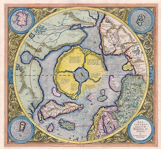
Most of the world has heard of the lost lands is Atlantis and maybe Lemuria as well. There are legends of lost islands or islands recorded during the so-called Age of Discovery that later ships attempted to find - for food and water, for supplies, a place to make repairs, to say, 'yep, I saw it too'.
Brooke-Hitching goes through and investigates 58 lands, features, islands and even a sunken city or two. I won't go into all of them or even list them all since they range from pole to pole. Across every continent, ocean and sea. Some I expected to hear about were not there but there are lots more, I never did before. I knew that California - actually Baja California - was once considered an island. And apparently so was Korea.
Many are considered the optical effects of a Fata Morgana - a mirage that distorts distant objects especially common in the polar regions. Then there are the desperately desired discoveries - the Northwest Passage, the Australian Inland Sea, the Terra Australis continent which is supposedly big enough to counter the 'weight' of the northern continents. Surprisingly, Google Earth still has a few of them listed - the island may not exist anymore or was never there but no one has gotten around to having it officially removed.
When dealing with islands, mapmakers would place them on charts for the simple reason, what if they are there? And they were certainly not going to call any explorer - who may have some rather powerful supporters and backers - a liar. It would be better to list an island that may be imagined rather than leave off one that may be there. There is also a great deal of confusion caused with positioning errors. Pepys Island is an example of such - it is actually one of the Falkland Islands and about 240 miles from it's original location.
Mayda or Asmaidas island was located about half way between Europe and the Maritimes of Canada, south of Greenland. In 1948, a ship was on it's way to London found itself in the area. The captain measured the depth - which was supposed to be at 2400 fathoms but sonar said 20. After repeated testing, a submerged land about 28 miles in diameter lay beneath the surface. Some geological event or the rage of the North Atlantic waves had scoured the island from the surface but at some point - it did exist.
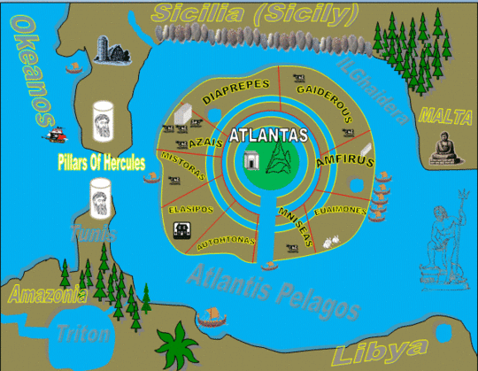
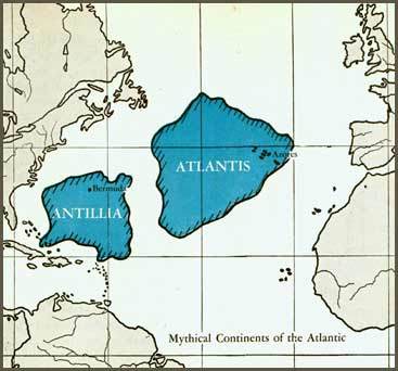
This is a gorgeous book, but it is essentially an encyclopedia listing unreal places on former maps. The entries are short, and largely reproduced from earlier works. There are some considerations of fantastical places such as Atlantis, Mu and Lemuria, but it is only enough to whet one's appetite.
An excellent book on what the ancients and medievals (and some not-so-ancients!) thought the world looked like. Whether that was massive southern continents, giants in Argentina, Chinese colonies in Western America, CIA-destroyed islands off the coast of Mexico, or many, many lost lands and islands of gold, this book has a rich panorama to present. I loved looking at the reproductions and photos of ancient maps. It is so fascinating to see how those who came before us viewed the world, and how they were motivated to discover it. Highly recommended for those who enjoy history or folklore. As some others have mentioned, the only real complaints are the alphabetic ordering instead of topical ordering (there are a lot of phantom islands and imaginary artic lands spread throughout the book) and sometimes the maps are a bit hard to read.
Fictitious places that have appeared on maps. Some are islands and lands reported seen by ships and explorers and been placed on maps. But turned out not to be when they were searched for. Some have not been removed from maps until this century - within the last 10 or 20 years. Other places have out of legends that were believed and sought for centuries. Some are just plain made up - occasionally for profit. There are pictures of maps showing all these places that don't exist - real maps. A thing I thought interesting was that Google earth maps of the seas are a combination of satelllite images and old British Admiralty maps. Makes for an interesting combination.
Fascinating book! And coming straight after The Cartographers, it was a great companion piece. It’s a historical non-fiction book first and foremost and the entries are listed in alphabetical order. But whereas some of these books can be DENSE and heavy, Edward’s writing made it very easily understood and not a slog to get through. Thoroughly fascinated by some of the entries that we once thought were real; even cooler is that some of these were only disproven in the last 10 years! 🤯