I saw this book on Amazon, offered at a cheap enough price to tempt my inner nerd into coming out and buying it (he doesn’t take a lot of tempting). I’m led to believe that the more expensive print version has the look of a coffee table book. If so I hope it has better maps than this Kindle edition. You get what you pay for.
This is a quick and easy read, in which the author looks at geographical oddities around the world, mostly arising from the drawing of frontiers. The bulk of the book looks at enclaves/exclaves, though towards the end the author digresses slightly into chapters covering unusual political arrangements such as Mount Athos, North Sentinel Island in the Bay of Bengal, and the British Crown Dependencies. There’s also a section on ghost towns.
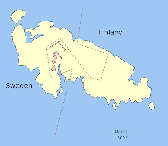
Each entry gets a page or two of text and an accompanying map, explaining the nature of the local peculiarity and how the situation arose. The map on the cover is a typical example. It shows the border between Sweden and Finland as it passes through the uninhabited Märket Island, in the Gulf of Bothnia. The boundary used to run in a straight line through the middle, and there’s a bizarre tale as to how it got its present zigzag shape. Another example is that of a hotel which has the French-Swiss border passing right through it. During WW2 German soldiers on occupation duty in France would dine in the restaurant, whilst members of the French resistance were holed up in rooms a few yards away, but on the Swiss side of the border and out of reach of their enemies. The island of Cyprus is somewhere with a whole series of strange arrangements, mainly of course due to the 1974 war, but also because of the presence of 2 sovereign British military bases.
The book features numerous towns and cities within Europe that have international borders running through them, noting that the adoption of the Euro and the Schengen Agreement have allowed these places to operate as integrated communities. I couldn’t help wondering how these locations have been affected by the COVID outbreak, which has seen boundary fences go back up in many parts of Europe.
Despite the numerous entries the book isn’t comprehensive. The author didn’t include the Indian enclaves with Bangladesh, some of which I believe have Bangladeshi enclaves within them. [However see update below dated 28 May, and Comment 14]. Nor did he include Oecusse (part of East Timor), or Kinmen (part of Taiwan). I was a little disappointed that he didn’t include Hyder, Alaska, a “pene-enclave” that I have actually been to (the book does though feature several other USA/Canada border anomalies).
Overall though I enjoyed the book. It’s an undemanding read for those who (like me) enjoy learning about these quirkier aspects of international politics.
UPDATE to my review on 28 May 2020. The author has responded (see comment 14 below) to the suggestion in my original review that the book was not comprehensive as it had not included the India/Bangladesh exclaves/enclaves, as well as missing a few others. The author advises that the India/Bangladesh issues were resolved a few years ago by exchanges of territory. He also explains why the other locations I mentioned were not included.
The author is Serbian which partially explains his fascination with international borders (land, sea, manmade), enclaves, condominiums, quadripoints, internal borders, unusual capitals, towns split by borders and ghost towns. I was sure the world was pretty wacky but this book proves it. Each locality is given a short history and some details of why it is and what it means. The sections are a bit uneven but overall it is a fun read and one that introduced me to numerous geographical and political complex issues.
This was expansive and comprehensive and I discovered that there are way more and way more types of unusual borders and enclaves throughout the world and through history that I had given credit for.
But while it was a good overview, with a lot of the entries, I was left wanting more. I wanted to explore the results of the borders, to explore the sociopolitical outcomes on both individual human level and on a greater societal level. The author does have areas where he goes into depth but it is more of a data driven angle and this results in a drier reading experience.
I'm something of a map nerd, I could spend hours just poring over maps of various kinds, so this was right up my alley. I definitely learned new stuff, from really obscure places to new information of less obscure places, and upon finishing the book (mostly read through it during my breaks at work) I will research my highlighted passages. Which leads me to my major annoyance with the book; the Kindle edition is a mess, its seems to have had a less than ideal conversion, I had a lot of trouble when I tried to mark/highlight single words or passage, for lack of a better word, the "zoning" on the pages seemed way off.
Now, I shouldn't let that take too much away from the book; its technical after all and could be down to my incompetence or an issue with the app, but its hard not to be somewhat annoyed. So, to be fair, IMO some sections could have merited more details than they received and in a few instances there wasn't an accompanying map for a certain location. But I would imagine the coffee table edition makes for a good acquisition.
Como dice el título, nos hallamos ante una recopilación de curiosidades fronterizas. Lo descubrí en un hilo maravilloso de mi hermano el fronterizo (tengo pendiente hacerle un chiste con fronterizo y borderline). Además de los mil millones de enclaves y exclaves que hay por el mundo (con Baarle como ejemplo canónico) aprendemos cobre muchas otras fronteras curiosas, como la redistribución de la isla de Märket, que debía incluir un faro en la parte finlandesa, pero además respetar tanto el 50% de área de cada país como el 50% de línea de costa, haciendo un interesante problema topológico.
Aprendemos también sobre la Passport Island, una isla artificial entre Arabia y Baréin construida para servir de aduana (luego ya le han añadido los centros comerciales y cosas así)
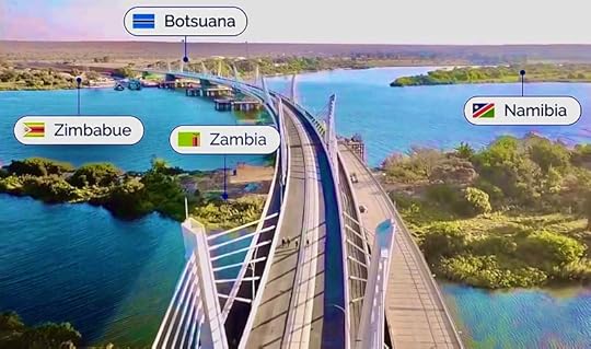
Me gustó mucho leer sobre uno de los pocos cuatrifinios (unión de cuatro territorios en un punto) de países en el mundo, en la cuádruple frontera entre Namibia, Zimbabue, Botswana y Zambia (aunque estos dos últimos dicen que sus fronteras están 200 metros río arriba y que en realidad hay dos trifinios)
Hay, en fin, varias decenas de curiosidades muy entretenidas. A los fans hardcore de la geografía curiosa este libro les encantará. A mi me ha entretenido bastante, y con eso me vale. Recomendable.
Interesting book on the whole - though sometimes slightly unclear explanations. Also not keen on the layout - the map and explanation are often on opposite sides of the paper!
Un libro para disfrutar viajando a lugares que, por alguna razón, tienen una situación geográfica particular. El libro tiene muchísimos datos y lugares bastante desconocidos, así como ilustraciones interesantes para cada uno.
Muy recomendable para todos aquellos interesados en geografía, en desconectar un rato a través de estos sitios un poco desconocidos para el público general. Además, debo hacer mención especial a una preciosa, cuidada y colorida edición.
Un buen regalo y autoregalo para todos aquellos a los que le guste el tema :)
Un libro muy didáctico, interesante y ameno para todos aquellos a los que nos gusta la geografía y la cartografía. Explica fronteras insólitas, territorios sorprendentes y curiosidades geográficas. Por ejemplo, datos tan curiosos como que el Monte Athos es el único territorio del mundo con una población exclusivamente masculina, o que en Baarle la nacionalidad de una casa la determina la orientación de la puerta de entrada. Todo un mundo por descubrir... me ha gustado mucho y lo recomiendo .
A good collection of geographical curiosities, not always well-researched and with differing depths of analysis and explanation. The lack of a common thread may be disappointing for some, but at the same time, and together with the quality of print, invests it with a coffee-table status. Very few people will resist the temptation of browsing through its pages and finding a few interesting quick reads.
I love enclaves and exclaves: this book makes the most of them, with usually a nice consistent graphic style that nine times out of ten makes the geography clear. But not always, and as the book moves on from enclaves to other border esoterica sometmies the determination to keep to a standard graphic colouring scheme gets in the way. But the text is often excellent and with enough history and poGreat find by my daiughter.litics to make a good explanation. It kept me entertained over a good few bedtimes, and I enjoyed it.
genuinely the best non-fiction book I’ve read in a while, would 100% recommend if you’re interested in geography, politics, or linguistics. or, if you’re looking for something new! also, the illustrations really help the book come to life. such a great gift!
Interesante colección de extrañas fronteras que te obligan a reflexionar sobre la arbitrariedad y caducidad de algo que normalmente parece prácticamente inamovible. Sin embargo, para mi gusto,Nikolic se centra demasiado en los hechos, sin ofrecer prácticamente ningún contexto o color. Hubiera preferido que se incluyeran menos ejemplos pero que estos estuvieran más desarrollados (prácticamente todos los ejemplos duran escasamente dos páginas), explicando que consecuencias reales han tenido o tienen esas anomalías geográficas, o los giros históricos que han llevado a esa situación. Mejorables también los mapas, cuya selección de colore (azul para la tierra en lugar del mar) los vuelven bastante confusos.
So.. This was a fun idea. I really liked some of the stories, but since they all consist of the same facts (area, population, etc) and are grouped bij a certain type of border, it gets quite boring after a while
If you like maps, quirks, and annoying your friends with mildly interesting but ultimately useless pieces of geographical trivia, then this is the book for you!
Zoran Nikolić’s book has the subtitle “Discover intriguing boundaries, territories and geographical curiosities” written on its cover. It is definitely a book for you, no matter if you think you already know everything worth knowing about this topic. Being a “border freak” myself, I enjoyed equally much reading about border areas that I have visited myself, or know of, as well as about geographical curiosities that were new to me. And there were surprisingly many of the latter, I have to admit. Nikolić’s book was finished early this year, so in addition to learning about “new” places, it was nice to get new information about several “old” ones as well. It was a great pleasure to read the background and concise presentation of the border areas and geographical curiosities that Nikolić has chosen for his book. These include places such as Brezovica, Caprivi Strip, Diomede Islands, La Cure, Likoma, Lutepää Triangle, Märket, Nahwa, North Sentinel Island, Northwest Angle, Oil Rocks, Passport Island, Pheasant Island, Ruitzhof, and Sokh, just to list a few. How many of these do you know of, and also the significance of? The map shown on the book cover, to give you the answer to one of the above places, is that of Märket, an island divided between Finland and Sweden. The island is very small, only about 300 metres long and less than 150 metres wide, yet the border that zigzags across the island is about 450 metres long! The amusing story behind this odd drawing of an international border is, of course, told in the book. This book comprises an impressive amount of interesting and entertaining facts which I won’t go into here. But, as always, it is almost impossible to prevent mistakes from slipping into the text. For example, the three-sided table decorated with three coats of arms is not the actual tripoint of Austria, Hungary and Slovakia, as suggested in the book; it is just a symbolic tripoint marker on Austrian territory. Or maybe one should call it a sculpture, as this particular border area is in fact a sculpture park. But the table is very close to the real tripoint, i.e. the exact place where these three countries meet. At the end of the book there is a glossary that lists two dozen or so important geographical concepts as well as their definitions. There is also a map key that clarifies the signs and colour codes used. Although the maps are simplified and yet very informative, it took me a while from time to time to “translate” some of them into the kind of maps that I’m used to and that I can easily understand – where water features are blue, not white or yellow as in the book, and where land is any other colour but blue. A subject index would also have been very helpful, one where the reader could quickly find the relevant page/s where, for example, specific countries and/or place names are mentioned. I cannot finish this review without pointing out that Finland did not gain independence after the Second World War, as the book claims. As all Finns know, Finland became an independent republic after the First World War. Nevertheless, in my opinion this this book is definitely a must for everyone who is even slightly interested in not only international but also national borders.
I could relate to the author and his passion for geography, especially geographic anomalies. Yet, I am no professional on the topic and still have much to learn. Maybe that's why I read through the whole book in one go.
While I knew about some places already, I still learnt more about most of those places, as the author provided some historical context, as well as information about the current situation. Some of the places mentioned in this Atlas were completely new to me.
Each place is described on 1-3 pages and most of them are provided with an insightful map. I felt this was a great lenght to describe each place.
There are some places which I believe could have made the book as well, like Hans Island or the disputed area between Sudan and Egypt.
Overall it's been a highly interesting read, as every place has it's own history and some fun facts you can learn. If you are interested in geography and want to learn more about some of the strangest borders / places, then I absolutely recommend this Atlas.
This book, currently available on Kindle Unlimited, is elegantly formatted for Kindle with nice, simple graphics and a clear layout. As the graphics are so simple, this is not really an intricate art book that is best appreciated in print as a visual and ergonomic pleasure. It works very well on the screen of an iPad. The content is quirky and informative, making for a pleasant read, but it is only a series of brief summaries. It would be nice to have a bit more detail in the narrative, more detailed maps and more photos of the places in question. But then we’d have an intricate art book that wouldn’t work on Kindle. As a piece of design, this digital edition strikes an excellent compromise and is very well put together. It’s a fun read, and may be idly perused again in future, just like a coffee table book would be.