This beatutiful book is a lavishly illustrated look at the most important atlases in history and the cartographers who made them.
Atlases are books that changed the course of history. Pored over by rulers, explorers and adventures these books were used to build empires, wage wars, encourage diplomacy and nurture trade.
Written by Philip Parker, an authority on the history of maps, this bookbrings these fascinating artefacts to life, offering a unique, lavishly illustrated guide to the history of these incredible books and the cartographers behind them.
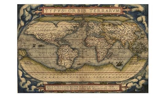
All key cartographic works from the last half-millennium are covered, including: The Theatrum Orbis Terrarum, considered the world’s first atlas and produced in 1570 by the Dutch, geographer Abraham Ortelius. The 17th-century Klencke – one of the world’s largest books that requires 6 people to carry it The Rand McNally Atlas of 1881, still in print today and a book that turned its makers, William H Rand and Andrew McNally into cartographic royalty.
The Publisher Says: This beautiful book is a lavishly illustrated look at the most important atlases in history and the cartographers who made them.
Atlases are books that changed the course of history. Pored over by rulers, explorers, and adventures these books were used to build empires, wage wars, encourage diplomacy, and nurture trade.
Written by Philip Parker, an authority on the history of maps, this book brings these fascinating artefacts to life, offering a unique, lavishly illustrated guide to the history of these incredible books and the cartographers behind them.
All key cartographic works from the last half-millennium are covered, including:
The Theatrum Orbis Terrarum, considered the world’s first atlas and produced in 1570 by the Dutch, geographer Abraham Ortelius,
The 17th-century Klencke—one of the world’s largest books that requires 6 people to carry it,
The Rand McNally Atlas of 1881, still in print today and a book that turned its makers, William H. Rand and Andrew McNally into cartographic royalty.
This beautiful book will engross readers with its detailed, visually stunning illustrations and fascinating story of how map-making has developed throughout human history.
I RECEIVED A DRC FROM THE PUBLISHER VIA EDELWEISS+. THANK YOU.
My Review: There is, on every gifting list, that guy. The one you just...can't...figure...out what to gift. Often they're smart, and deeply interested in something, usually something you've never heard of or think is so boring you'd rather pluck your nose hairs with needlenose pliers than think about.
This is the present you need for that guy, whatever gender they present and/or identify as. Politics? You damned well better bet that politics-obsessed guy knows about maps and their political implications. Author Parker does, too. There's a huge amount of trouble stirred up in this world by making changes to maps. The Gulf War of 1990 was sparked when Saddam Hussein published a map showing Kuwait as Iraq's nineteenth province. Yes, to be clear, it was an excuse but it passed the sniff test around the world...that is how powerful a map is as a political statement.
India and Pakistan, created from one VAST swathe of land by a few strokes of the Imperial British pen...decades of war over Kashmir being there not here, here not there. Israel? Do I even need to type it? The Toledo Strip in the US? Your politics-obsessed guy The history guy...the one who, when awakened from sound slumber can rattle off the presidents of the United States in order starting from the ninth (actually pretty interesting, William Henry Harrison, he was...oh, right, back to what I was saying before) or the Khmer Empire's date of foundation (or as close as we can get, anyway, the seventh century CE wasn't a time with hugely good surviving material culture in writing since they didn't have...yeah, yeah, okay) certainly knows what maps really mean in the world.
What better way to chart a culture's opinion of itself and its history, not to mention its future, than to look at its maps? Or maybe even more importantly, who drew or draws its maps and why...the US Government produced the Atlas of the United States on paper until 2007 then digitally until 2014, and now...Google does it. The GPS revolution, the web that Time Berners-Lee imagined and enabled with his hyperlinking technology, all depend on an infrastructure less than half a century old. Atlases and maps are centuries old. Paper is ephemeral, it's true, but pixels are barely even real. What makes a book like this one so fun for that guy to read is that it's readable. I adored GLOBES: 400 Years of Exploration, Navigation, and Power when I reviewed it for #Booksgiving in 2017 (and it's still available, in stock and ready to ship!), but it wasn't as readable as this book is. Part of that was the coffee-table-ness and part of it was the brief it set itself. This, too, is a coffee table book but it's got a different brief. The globe is an object with a special history, one that includes the social and historical importance that atlases have, but also a physicality and social statement of power and prestige that requires a denser academic argument than does a maps-and-atlases book. It also has an earlier end-point than does a book of map-making and -publishing history given that we are amid a technological revolution with even greater import to maps and atlases than to globes. They're beautiful objects but their role has become completely virtual with the massive increases in computing power and digital storage technology.
The text of The Atlas of Atlases asks little enough of you to make it possible to skim while sitting around post-gifting and making small talk. There is enough heft to the subjects covered, from Ortelius's first-ever compilation of printed maps that he entitled "Atlas" after the world-supporting Titan of that name in 1570, to Google Maps and its ever-expanding and slightly threatening ubiquity, to keep anyone in this interest group riveted. The look of surprised happiness on that guy's face as this multi-layered feast for the eyes and the brain is revealed will more than recompense the mere $40 (less if you shop for it) you shell out. Hard to buy for people, when they get this kind of gift, are always so satisfying to please.
This one arrived as a suggestion for Michelle on our annual wedding anniversary bookstore trip. I have been fascinated by maps from my earliest days so this book was pretty much made with me in mind. It's occasionally dry--what does one expect?--but it does a thorough job with lots of illustrations, showing the history of mapping from the earliest days right up to the Google Street cars.