
Norene Moskalski's Blog: Reviews from Other Websites
March 10, 2016
NEW BEACH GRASS FOR ATLANTIC OCEAN SAND DUNES
VOLUNTEERS ARE NEEDED TO HELP REPLENISH THE ATLANTIC OCEAN SAND DUNES WITH BEACH GRASSES Have you ever volunteered to replenish the beach grasses along the Atlantic Ocean coast in Delaware? It is one of the most fun-filled days of activity at the beach. Young grasses are provided to the volunteers, a brief planting lesson is given, and small groups of volunteers are assigned to different areas of the sand dunes to begin planting the new beach grasses. What a great way to help the environment, soak in some early spring sun, and make new friends, too!
Jennifer Luoma, from DNREC, coordinates the program, explaining how to participate as a volunteer:
"The 2016 Beach Grass Planting will be from 9 AM to 12 noon on Saturday, March 19, 2016. If you and your family and friends are able to volunteer, please register online at:
http://www.dnrec.delaware.gov/swc/Shoreline/Pages/BeachGrassPlanting.aspx
(If you have trouble reaching the registration site, please try updating your browser or using Google Chrome.)
Please note, that we will be planting in several areas and some require more volunteers than others. Also, even though an area is listed, it may not be ready for beach grass by the time of the event. Therefore, we would greatly appreciate it if you make at least 3 choices in order of preference. We will do our best to assign you to your first choice, but this is not guaranteed.
Please expect to get an e-mail confirming your registration and giving you your assigned site and other information about a week prior to the event.
If you do not wish to register on-line or have any questions about the planting, please give me a call at (302) 739-9921 or send me e-mail at Jennifer.Luoma@state.de.us.
Thank you for volunteering!"
Jennifer L. Luoma
DNREC, Division of Watershed Stewardship
89 Kings Highway
Dover, DE 19901
(302) 739-9921


December 6, 2015
OLYMPIC WATER SPORTS IN POLLUTED BRAZILIAN COASTAL WATERS?
POLLUTED COASTAL WATERS IN BRAZIL EXTEND FURTHER SEAWARD THAN ORIGINALLY THOUGHT All eyes are on the polluted coastal and inland waters of Brazil where the next Olympics' water sports will soon be held. The main question: Can the pollution be cleared in time for the Olympics? The next question: If not, what precautions should the Olympiads take before entering the water?
Recent reports on Brazil's water quality are listed below, credits given to Google Alerts for sending out these resources to subscribers' interested in water pollution and its solution. Let's hope that the healthy Olympiads will compete in clean, clear waters.
Rio Water Pollution Extends Far Offshore, Report Finds
TIME
Water pollution in Rio de Janeiro extends farther offshore than previously realized, according to a new report released in advance of the Olympics to ...
AP test: Rio Olympic water badly polluted, even far offshore - Yahoo News
Rio 2016 - New testing finds Olympic water pollution extends offshore - Sail World (press release)
Rio water pollution stretches beyond shoreline, AP tests show - ESPN
Full Coverage
September 1, 2015
High Bacterial Count At Slaughter Beach, Delaware
NO SWIMMING AT SLAUGHTER BEACH UNTIL DNREC RESAMPLES THE WATER From the DNREC Beach Monitoring List <dnreclist@state.de.us>3:56 PM (3 hours ago), we have a new report of unsafe bacterial counts in the water at this beautiful replenished beach. Please heed the warning about no swimming until further notification from DNREC and pass this warning along to any beachgoers. Check DNREC's website daily for updates on this problem. DNREC's formal advisory follows:
Type: Recreational Water Advisory
Reason: Bacteria
Location: Slaughter Beach
Start Date: 09/01/2015
End Date: 09/02/2015
Description: Recreational Water Advisory
Comments: This recreational water advisory is a caution regarding swimming at Slaughter Beach due to elevated enterococcus indicator bacteria in a recent sample. Slaughter Beach has a robust shorebird population which can contribute to higher levels of fecal indicator bacteria. Re-sampling will be conducted until we receive water quality results that meet swimming water criteria. For more information go to http://apps.dnrec.state.de.us/RecWater/
May 19, 2015
DNREC BEACH ADVISORY FOR SLAUGHTER BEACH, DELAWARE
IT'S THAT TIME OF YEAR AGAIN: RECREATIONAL WATER USE ADVISORY! 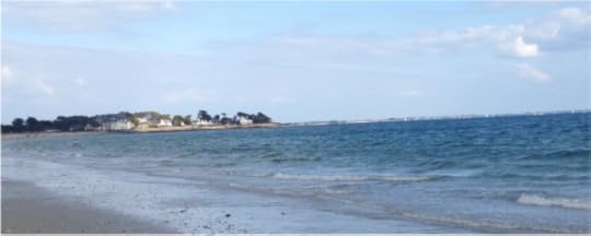 The Delaware Department of Natural Resources and Environmental Control (DNREC) cautions persons and their pets to be aware of announcements regarding bacteria content in the Delaware Bay, Atlantic Seashore, and recreational bodies of water in the state. To receive their messages by email, simply sign up on their website:
http://www.dnrec.state.de.us/dnreceis/Div_Water/Apps/RecWater/Asp/RecWaterPublic.asp
This is the type of message they send out, followed up with the conditions every day until the problem has been resolved:
DNREC Beach Monitoring List <dnreclist@state.de.us>4:54 PM (6 hours ago)
Reply to DNREC_Beach_Mo.
Type: Recreational Water Advisory
Reason: Bacteria
Location: Slaughter Beach
Start Date: 05/19/2015
End Date: 05/20/2015
Description: Slaughter's Beach is located east of Milford, DE
Comments: This recreation water advisory is a caution regarding swimming at Slaughter Beach, this area was observed to have numerous seagulls at the time of sampling and has experienced rainfalls this week. Rainfall may cause an elevation of bacteria levels in natural waterways due to runoff from the land. Re-sampling will be conducted until we receive water quality results that meet swimming water criteria.
The Delaware Department of Natural Resources and Environmental Control (DNREC) cautions persons and their pets to be aware of announcements regarding bacteria content in the Delaware Bay, Atlantic Seashore, and recreational bodies of water in the state. To receive their messages by email, simply sign up on their website:http://www.dnrec.state.de.us/dnreceis/Div_Water/Apps/RecWater/Asp/RecWaterPublic.asp
This is the type of message they send out, followed up with the conditions every day until the problem has been resolved:
DNREC Beach Monitoring List <dnreclist@state.de.us>4:54 PM (6 hours ago)
Reply to DNREC_Beach_Mo.
Type: Recreational Water Advisory
Reason: Bacteria
Location: Slaughter Beach
Start Date: 05/19/2015
End Date: 05/20/2015
Description: Slaughter's Beach is located east of Milford, DE
Comments: This recreation water advisory is a caution regarding swimming at Slaughter Beach, this area was observed to have numerous seagulls at the time of sampling and has experienced rainfalls this week. Rainfall may cause an elevation of bacteria levels in natural waterways due to runoff from the land. Re-sampling will be conducted until we receive water quality results that meet swimming water criteria.
March 13, 2015
1 + 1 = 3 SYNERGY! NOCTURNE, OPUS 1: SEA FOAM, WHERE PASSIVE BACTERIA GO VIRAL!
1 + 1 = 3 Synergy!
In Nocturne, Opus 1: Sea Foam , a physician researches the concept of synergy, a combination of elements that produce better results than would be expected by using each element separately.
The American Institute for Cancer Research (AICR) posits the use of synergy as a possible area of research for studying how to boost the protective effect of phytochemicals in foods. The AICR stated that "no single food or food component can protect you against cancer by itself. But scientists believe that the combination of foods in a predominantly plant-based diet may. There is evidence that the minerals, vitamins, and phytochemicals in plant foods could interact in ways that boost their individual anti-cancer effects. This concept of interaction, where 1 + 1 = 3, is called synergy."
Synergy plays an important role in Nocturne, Opus 1: Sea Foam . What combination of elements do you think a Native American health worker experiments with to stop the deadly course of Bacillus nocturne , a normally passive waterborne bacteria?
February 18, 2015
ANNUAL BEACH GRASS PLANTING ON DELAWARE BEACHES
VOLUNTEERS NEEDED FOR REPLENISHING BEACH GRASSES ON DELAWARE'S SAND DUNES AND SHORES 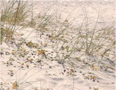 The 26th Annual Delaware Beach Grass Planting will be held from 9 a.m. to 12 noon on Saturday, March 21, 2015. Volunteers are needed to help plant Cape American grasslings on Delaware's ocean shores and along one Delaware Bay beach.
No experience is necessary! DNREC associates will be giving free lessons on how to plant beach grasses, and they will provide bundles of young grasses for each volunteer to plant.
Come out and help make Delaware's shores a better place! Meet some new friends and learn about the sand dunes. Bring your children to help you plant and learn valuable information about caring for our environment.
Together, we can make Delaware's sand dunes greener!
Contact:
Jennifer Luoma at (302) 739-9921 or by email at Jennifer.Luoma@state.de.us
Jennifer L. Luoma
DNREC, Division of Watershed Stewardship
89 Kings Highway
Dover, DE 19901
Or register on line:
http://www.dnrec.delaware.gov/swc/Shoreline/Pages/BeachGrassPlanting.aspx
Thank you, Jennifer and DNREC, for helping us to care for our environment!
The 26th Annual Delaware Beach Grass Planting will be held from 9 a.m. to 12 noon on Saturday, March 21, 2015. Volunteers are needed to help plant Cape American grasslings on Delaware's ocean shores and along one Delaware Bay beach. No experience is necessary! DNREC associates will be giving free lessons on how to plant beach grasses, and they will provide bundles of young grasses for each volunteer to plant.
Come out and help make Delaware's shores a better place! Meet some new friends and learn about the sand dunes. Bring your children to help you plant and learn valuable information about caring for our environment.
Together, we can make Delaware's sand dunes greener!
Contact:
Jennifer Luoma at (302) 739-9921 or by email at Jennifer.Luoma@state.de.us
Jennifer L. Luoma
DNREC, Division of Watershed Stewardship
89 Kings Highway
Dover, DE 19901
Or register on line:
http://www.dnrec.delaware.gov/swc/Shoreline/Pages/BeachGrassPlanting.aspx
Thank you, Jennifer and DNREC, for helping us to care for our environment!
December 2, 2014
DELAWARE'S FERAL, ABANDONED, STRAY, AND LOST CATS
WILDLIFE IS PRECIOUS IN DELAWARE: FERAL CATS FIND A PLACE AS COMMUNITY CATS OR NEIGHBORHOOD CATS 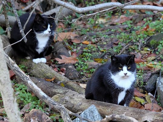
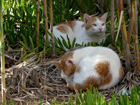
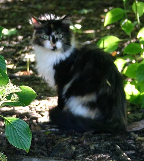 One of the things that I love about living in Delaware is the state's progressive attitude toward all wildlife. In Delaware, for example, it is a felony, a criminal offense, to harm any feral or pet cat. I've included a link below about Delaware's legal designation of feral cats as "community cats" or "neighborhood cats." Not only do they protect feral cats, they offer assistance to farmers and homeowners to help them find a peaceable way to integrate feral cats into their communities.
http://www.nokilldelaware.org/community-cats/
I became one of Delaware's feral cat caretakers because of an important phrase I've heard throughout my life: "When I was hungry, you gave me food to eat..." which I believe was meant to apply to every one who comes to our door in hunger.
In fact, many people throughout the United States now recognize our responsibility for caring for feral cats. Alley Cat Allies reports on their website (www.alleycat.org) that "Intentionally killing a cat is a criminal offense in all 50 states and the District of Columbia, regardless of ownership. Anti-cruelty laws apply to all cats— companion, abandoned, lost, and feral."
All life is precious, in ways we sometimes do not completely understand. That is why we have laws to guide us. Thank you, Delaware, and state and national legislators, for defining a path to progress.
One of the things that I love about living in Delaware is the state's progressive attitude toward all wildlife. In Delaware, for example, it is a felony, a criminal offense, to harm any feral or pet cat. I've included a link below about Delaware's legal designation of feral cats as "community cats" or "neighborhood cats." Not only do they protect feral cats, they offer assistance to farmers and homeowners to help them find a peaceable way to integrate feral cats into their communities. http://www.nokilldelaware.org/community-cats/
I became one of Delaware's feral cat caretakers because of an important phrase I've heard throughout my life: "When I was hungry, you gave me food to eat..." which I believe was meant to apply to every one who comes to our door in hunger.
In fact, many people throughout the United States now recognize our responsibility for caring for feral cats. Alley Cat Allies reports on their website (www.alleycat.org) that "Intentionally killing a cat is a criminal offense in all 50 states and the District of Columbia, regardless of ownership. Anti-cruelty laws apply to all cats— companion, abandoned, lost, and feral."
All life is precious, in ways we sometimes do not completely understand. That is why we have laws to guide us. Thank you, Delaware, and state and national legislators, for defining a path to progress.
September 17, 2014
Collapse of the West Antarctica Ice Sheet Continues
The West Antarctica Ice Sheet Continues to Melt Away . . . As reported in The New York Times:
"The collapse of large parts of the ice sheet in West Antarctica appears to have begun and is almost certainly unstoppable, with global warming accelerating the pace of the disintegration, two groups of scientists reported Monday.
"The finding, which had been feared by some scientists for decades, means that a rise in global sea level of at least 10 feet may now be inevitable. The rise may continue to be relatively slow for at least the next century or so, the scientists said, but sometime after that it will probably speed up so sharply as to become a crisis.
“This is really happening,” said Thomas P. Wagner, who runs NASA’s programs on polar ice and helped oversee some of the research. “There’s nothing to stop it now. But you are still limited by the physics of how fast the ice can flow.”
Read more: http://uproxx.com/gammasquad/2014/05/science-we-may-all-soon-be-drowning-because-the-arctic-ice-is-melting-hella-fast/#ixzz31YOHvr7N
Follow us: UPROXX on Facebook
August 16, 2014
CROWDSOURCED DATA COLLECTION REQUESTED BY ICOAST
INNOVATION AND CITIZEN SCIENCE: CROWDSOURCED DATA COLLECTION REQUESTED BY ICOAST "Crowdsourced data from iCoast will enhance predictive modeling of coastal erosion to better inform emergency managers, planners, and residents of coastal vulnerabilities in their regions," explains Ethan Alpern of the United States Geological Survey as they introduce their new iCoast data analysis to coastal volunteers.
The USGS is seeking volunteers to help analyze photographs of pre-storm and post-storm shorelines in the United States. A letter from Ethan Alpern describing the project follows:
USGS iCoast – Did the Coast Change?
The U.S. Geological Survey has launched a new crowdsourcing application called “iCoast – Did the Coast Change?” to show you these coastal changes from extreme storms.
iCoast allows citizen scientists to identify changes to the coast by comparing aerial photographs taken before and after storms.
Crowdsourced data from iCoast will help USGS improve predictive models of coastal change and educate the public about the vulnerability of coastal communities to extreme storms.
Aerial Imagery of the Coast Before and After Storms
Since 1995, the USGS has collected more than 140,000 aerial photographs of the Atlantic and Gulf coasts after 24 hurricanes and other extreme storms. Just for Hurricane Sandy alone, more than 9,000 aerial photographs were taken a week after the storm.
USGS acquires high-resolution oblique aerial photography after extreme storms and compares them to imagery collected before the storms. These aerial photographs are taken at a low altitude to capture a small area of the coast. USGS collects aerial imagery to ground truth and improve the USGS coastal change probability models.
“Computers cannot yet automatically identify damages and geomorphic changes to the coast from the oblique aerial photographs,” said Sophia B. Liu, USGS Mendenhall Postdoc Fellow. “Human intelligence is still needed to finish the job.”
Without the personnel or capacity to analyze all the photographs taken after every storm, the USGS decided to launch a citizen science project, asking citizens to help identify changes to the coast while also gaining knowledge about coastal hazards.
USGS determines probabilities of hurricane-induced coastal change for the Atlantic and Gulf coasts of our Nation to better inform evacuation, response, preparedness, and mitigation efforts.
The Power of Citizen Science and Crowdsourcing
Analyzing the aerial photographs to identify storm damage will help coastal scientists refine their predictive models of coastal erosion and damage caused by extreme storms. Currently, these mathematical models are derived from dune elevation and predicted wave action during storms. Adding the human observations will allow the scientists to validate the models and to provide better predictions of damage before storms occur.
“After an event like Hurricane Sandy there is always a great interest in our photographs,” said Barbara Poore, USGS Research Geographer. “The USGS iCoast team hopes that people will learn about coastal change and about their personal vulnerabilities to extreme storms.”
Integrating Citizen Science into the Model
Research on storm-induced coastal change hazards provides the data and modeling capabilities to allow the USGS to identify areas of the U.S. coastline that are likely to experience extreme and potentially hazardous erosion during hurricanes or other extreme storms.
To assess coastal vulnerability to extreme storms, the USGS has developed a Storm-Impact Scale to produce Coastal Change Probability estimates.
Hurricane-induced water levels, due to both storm surge and waves, are compared to beach and dune elevations to determine the probabilities of these types of coastal change processes:
Beach Erosion occurs when wave runup is confined to the beach.Dune Erosion occurs when the base or toe of the dune is eroded by waves and storm surge.Overwash occurs when sand is transported and deposited landward over the beach and dune by waves and storm surge.Inundation occurs when the beach and dune are completely and continuously submerged by storm surge and wave runup.
Benefits of the USGS iCoast Project
There are scientific, technological, and societal benefits to the iCoast project. The crowdsourced data from iCoast will enhance predictive modeling of coastal erosion to better inform emergency managers, planners, and residents of coastal vulnerabilities in their regions.
Citizen science projects like iCoast serve the cause of Open Government and Open Data, by sharing USGS aerial imagery with the public. iCoast can also be a great tool for marine science educators to create interactive and fun lessons related to coastal hazards.
How to Use iCoast:
http://www.usgs.gov/blogs/features/usgs_top_story/usgs-icoast-did-the-coast-change/?from=image
August 6, 2014
LEWES BEACH NAMED ONE OF TWENTY-TWO BEAUTIFUL BEACHES IN THE UNITED STATES BY KATIA HETTER OF CNN
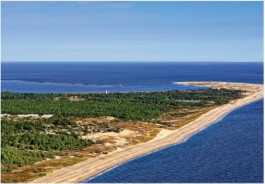 CAPE HENELOPEN PHOTO COURTESY OF JACK KOFOED. In her August 13, 2013 feature story, "22 Can't-Miss U.S. Beaches," Katia Hetter of CNN named Lewes Beach, Delaware, one of twenty-two unique, enjoyable, and beautiful beaches in the United States. Let's watch for Hetter's 2014 evaluation of the best beaches in the United States!
Reviews from Other Websites

By booklover
A great book with believable, rounded characters in a fast moving plot that is enhanced by its engaging subplots. Everything ties together in the end, but until then, we're kept guessing ...more
A great book with believable, rounded characters in a fast moving plot that is enhanced by its engaging subplots. Everything ties together in the end, but until then, we're kept guessing ...more
- Norene Moskalski's profile
- 33 followers

