Where did Montreal’s Lac St. Pierre go?
A large lake and river appear on pre-1850 maps on Montreal Island (1). Present day, this area is dry land and accommodates the Turcot rail yard and traffic interchange (2) at the base of the St.Jacques cliff.
Had French explorers based their maps on indigenous ‘folklore’? Was this a mythological lake, much like dragons and sea monsters ascribed to unexplored reaches?
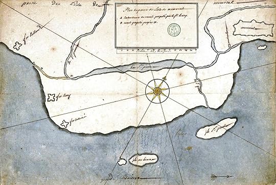
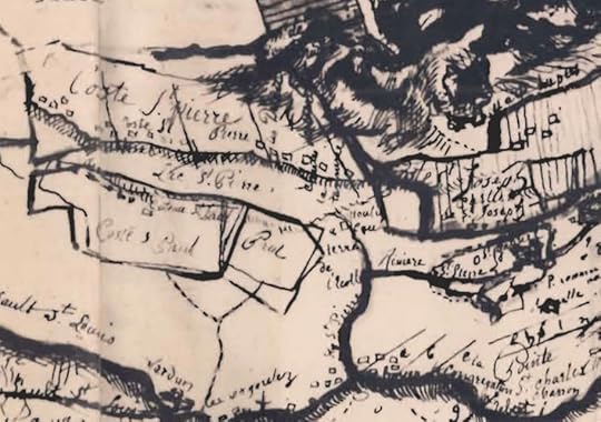
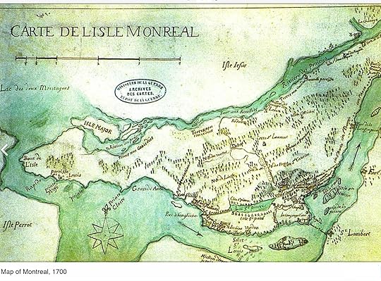 Figures 1 & 2: 1702 Map of Montreal Island
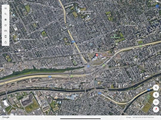 Figure 3- Turcot rail yard and traffic interchange at base of St.Jacques cliff
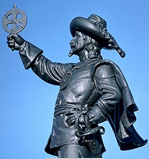
Perhaps this was an error from crude instrumentation early explorers relied upon. Yet, this instrumentation still remains in reliable use today. A compass is familiar to every hiker. The sextant is required on both ship and plane to determine longitude and latitude. A Pelorus, coupled with a lubber line, continues to be used in yachting to determine between vessels. Champlain’s useful astrolabe is also famous for having been lost in 1603 and found in 1867 in the upper Ottawa Valley.
Champlain would have used this astrolabe to measure the inclination of sun and stars from the earth’s horizon in consultation with astrological tables to fix the position of Lac St. Pierre and its inlet/outlet Rivière St. Pierre crossing Montreal island.
 Figure 3: Speculative model of Lac St. Pierre, 1600’s
 Lac St Pierre had existed…Where did it go?
In 1611, Samuel de Champlain described Petit Lac St. Pierre as “one of the finest spots on the St. Pierre River” . Water flowed from Mont Royale, in waterfalls over the St. Jacques cliff. Known as le Petit Lac St. Pierre, differentiating it from the St. Lawrence River’s widened reach, it as also referred to as Lac a la Loutre (Otter Lake) (3) due to an abundant presence of fish and wildlife.
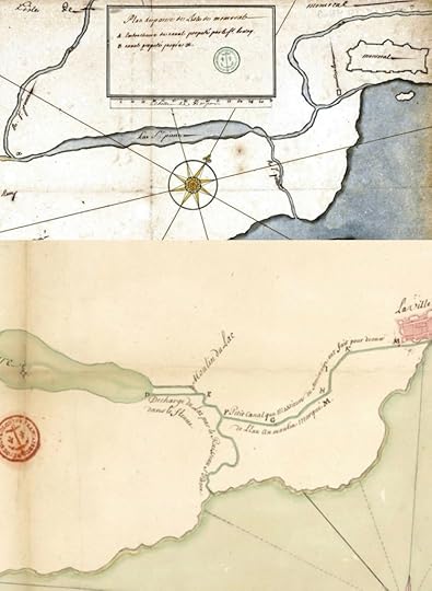
By 1640, the village of Montreal was established, nearby. Champlain ordered trees cut down on the shores of the lake, to make ready for building. He then proposed changing to the course of the Rivière St. Pierre, by digging the Saint Gabriel canal (4). This would allow canoe’s to bypass the Lachine Rapids, eliminating a lengthy portage. The canal would also provide sufficient discharge to run mills and feed industrial growth, west of Montreal.
Figure 4 (top): original river
Figure 4 (bottom): St. Gabriel canal.
Three four mills (9) and several tanneries, in support of the French fur trade, were subsequently located on the banks of the St. Pierre lac and rivière. Complementary industries, of tallow factories and slaughter houses, soon followed.
Figure 5: Populated shores of Lac St. Pierre (early 1700’s)
The tanning process, converting hides into rawhide and leather, required softening skins in a lime pit, pounding skins to remove flesh and fat, before soaking them in urine, painting with a lime mixture and finally soaking them in a tanning solution of eggs, brain and other noxious solutions. The former pristine waters of St. Pierre transformed into a swampy open sewer of industrial refuse, toxic wastewater and human sewage.
Figure 6, a 1815 map (5) of Montreal, shows Lac St. Pierre, with the Rivière St. Pierre, flowing through Verdun, to Isle St. Pierre (present-day Nun’s Island). A small tributary still flows over the high embankment to the north.
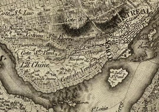 Figure 6: 1815 map, west of Montreal
 By 1831 (6), Lac St. Pierre disappeared from a survey of Montreal. Rivière St. Pierre was still visible, north of the newly constructed Lachine canal. The Tannery district is identified, to the west of the city and north of the ‘little River’ and Lachine canal.
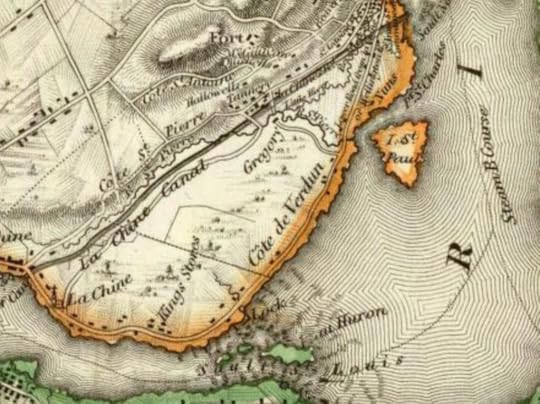 Figure 7: 1831 map, west of Montreal
By 1825, the ‘politically charged’ construction of the 4.5 km Lachine Canal was completed, and extended from the Port of Montreal to the widened reach of Lac St. Louis of the St. Lawrence River. In my research I found no mention of material deposition, however, rock blasting, digging by hand was done by Irish labourers, and carted away by wagon (7)(9). Excavated materials were likely conveniently deposited into the nearby now-swampy and polluted basin of Lac St. Pierre.
From Figure 7, one can see the Rivière St. Pierre runs adjacent and was not incorporated into the canal, except for a small redirected portion. This was required to accommodate snow runoff, collecting in the former Lac St. Pierre basin, flooding the excavation. In the spring of 1824, the Rivière St. Pierre turned into a torrent, further necessitating construction of tunnel, allowing Rivière St.Pierre to flow under the canal (8).
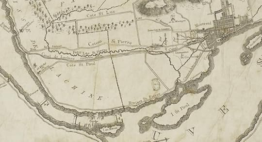 Figure 8: Lachine Canal and Petit Lac St. Pierre, 1834
In 1832, in the interest of public health, 350 meters of the foul Rivière St. Pierre was diverted into a vaulted stone conduit, known as the William Collector. Gradually, more of the Rivière disappeared into Montreal’s growing sewer system(10). With time, occasional artifacts of the former, buried and forgotten, Lac and Rivière would surface (11).
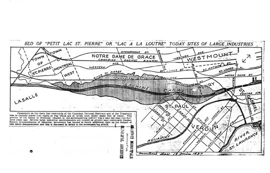 Figure 9: Montreal Star article, June 19, 1937 (text inscribed below)
 “Passengers on the main line, westwards of the Canadian National Railways, and of the Tramways line to Lachine, travel over rights of way which are at levels once under many feet of water. This portion of the Island of Montreal (shaded in the accompanying sketch) was a lake less than 200 years ago. Several large industrial establishments are located on ground once continually flooded.” (11)
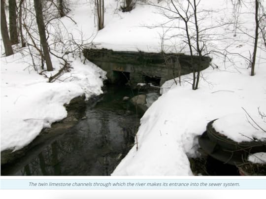
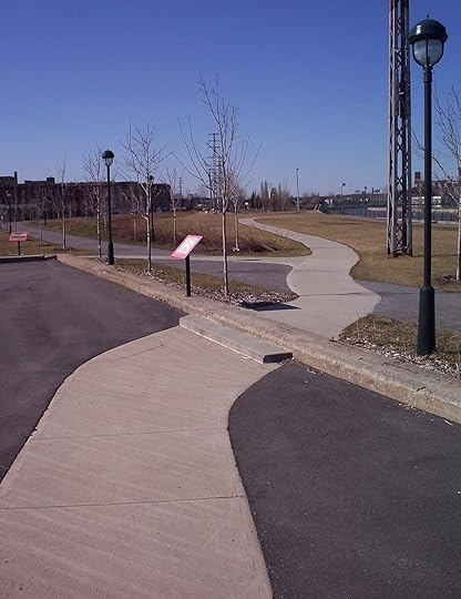
Figure 10: Only a 200 meter remnant of the Rivière remains, a contaminated creek traversing Meadowbrook Golf Club, in Montreal West (12).
An environmental group, ‘Les Amis du Parc Meadowbrook, is working to protect the remain of this historical waterway.
Adjacent to the Lachine Canal a memorial has been built, a reminder of the Lac.
Figure 11: Memorial to the St. Pierre Lac and Rivière.
Les Amis du Parc Meadowbrook has published an enlightening map of other waterways that have disappeared into Montreal’s sewers. (13)
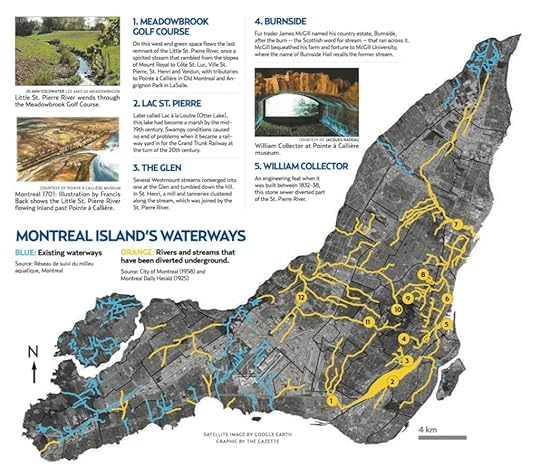 Figure 12: Montreal Island’s waterways, existing and lost
And that is the sad fate of Montreal’s Lac St. Pierre.
References:
(1) Description generally de L’isle de Montreal, Coste de Francois Vachon de Belmont, 1802, Archives de la Ville de Montreal
(2) Google Earth Maps
(3) La Petit Lac Saint-Pierre et la Falaise Saint-Jacques, 1 July, 2022, souvenirsetmemoirescdn.com
(4) Saint Pierre River (Montreal) — Wikipedia
(5) Topical Map of the Province of Lower Canada, 1815, David Rumsey Historical Map Collection
(6) Map of the District of Montreal, Lower Canada, 1831, David Rumsey Historical Map Collection
(7) The Construction of the First Lachine Canal, 1815-1826, J.J.Tulchinsky, June 1960, MA Submission, McGill University
(8) Building the Lachine Canal, Janice Hamilton, March 15, 2015, Genealogyensemble.files.wordpress.com
(9) The St. Pierre River: Remembering a Historical Montreal Waterway, L.Legault, Friends of Meadowbrook Park
(10) Following Rivière St. Pierre, Montreal’s Most Famous Lost River, 5 Part Series, March 3, 2009, Spacing, Canadian Urbanism Uncovered
(11) Montreal to Bury St. Pierre River on Meadowbrook Golf Course, Marian Scott, Nov 18, 2021, Montreal Gazette
(12) Montreal Island Lost Rivers, Marian Scott, July 9, 2018, Montreal Gazette