
113. Designing new towns (on the edge)
New towns?
Recently, I served on a fascinating all-day design review panel for the Chase Park and Crews Hill sites in Enfield. Just four days later – and entirely unrelated – the New Towns Taskforce, Report to Government was published, and these very sites were identified as the core of a proposed new town on the edge of London. However, while our review focused on allocations for 3,700 and 5,600 homes respectively, the conversation was now about 21,000 homes across both sites and beyond, biting off almost 900 hectares from the green belt.
Looking across the 12 potential new towns identified by the Taskforce, it’s striking how many are edge-based rather than free-standing. They broadly fall into four categories:
Free-standing new towns – Adlington, Heyford Park, TempsfordTown satellites (standalone but immediately adjacent to an existing large town) – Marlcombe, Worcestershire ParkwayUrban extensions (expanding existing limits) – Brabazon & West Innovation Arc, Crews Hill & Chase Park, (northern) Milton KeynesUrban infill (within large cities) – Leeds South Bank, Manchester Victoria North, (central) Plymouth, Thamesmead WaterfrontThis list differs markedly from the post-war new towns which were largely independent settlements, with a few town expansions such as Northampton and Peterborough. By contrast, nine of today’s 12 proposed ‘new towns’ are either enveloped by, extensions of, or sitting so close to existing urban areas that they will be dominated by their host settlements.
Are these truly new towns? I doubt they will be perceived as such when built (much like Northampton and Peterborough today), and perhaps that doesn’t matter, but in design terms it certainly adds complexity. Not only are you creating something new but also fundamentally reshaping something that exists.
Where this occurs wholly within the existing perimeter, densification can naturally create new sub-centres – Plymouth’s emerging city centre or Leeds South Bank, for example. But where growth pushes beyond the existing urban edge, the challenge is to make places that feel distinct, are appropriately dense, and remain sensitive to their edge conditions. England’s record here is poor: over half of rural-edge schemes scored “poor” or “very poor” in The Housing Design Audit for England.
Two sites on the edge
Chase Park and Crews Hill illustrate these edge conditions vividly – but in contrasting ways.
Chase Park currently exists only as countryside. The A110 defines London’s edge here, separating low-density suburban housing from open fields. From the suburban back gardens you can gaze out to green belt farmland – a quintessential urban-rural boundary. Bus routes connect to commuter rail, yet the area remains car-dependent, with generous private parking and limited walkability.
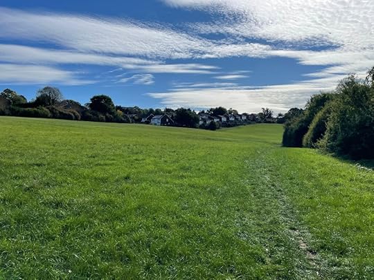 Chase Park, rolling green hills and the urban edge beyond
Crews Hill, by contrast, already has a railway station but little resident population or intrinsic quality. Instead, it consists of a street along which are strung a succession of garden centres, nurseries and one large residential cul-de-sac (the only part that is not currently green belt). It feels suburban, despite being within the green belt – a textbook case of ‘grey belt’. Bus links are poor, the M25 roars nearby, and the place lacks any of the arcadian qualities found at Chase Park.
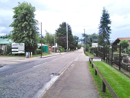 Crews Hill, defined by its string of garden centres
If these two sites form the nucleus of a larger ‘new town’, then like most of the other selections of the New Towns Taskforce, this will be a town truly on the edge; in geographic terms, a new outer suburb of London. Three critical issues follow – density, landscape, and dealing with the ‘stuff’ that is already there.
Density at the edge
The Taskforce calls for ‘ambitious density’ – enough to support walking, public transport, and vibrant neighbourhood life. It stops short of defining figures, passing that buck to government; perhaps a wise move given how different each of the sites are and the need for an ambitious but also ‘appropriate’ density for each.
So what about Chase Park and Crews Hill? 21,000 homes implies around 50,000 residents – a town the size of Durham sitting on London’s fringe. Such a population demands a full suite of services, a town centre, and strong public transport – otherwise the scheme risks becoming another car-dependent sprawl.
The ‘Goldilocks’ density – high enough to sustain amenities but low enough to retain liveability – is probably between 50–80 dwellings per hectare (on average). Interestingly, the best scoring schemes in The Housing Design Audit for England averaged 56 dwellings per hectare, so the good news is that we are much better at building at these sorts of densities.
At 50 dph, rising to perhaps 150 dph in the town centre, 21,000 homes would require about 400 hectares – less than half the 884 hectares identified. That leaves ample land for green infrastructure and biodiversity, crucial for an edge-of-town setting. Without this, we risk repeating the stark edges found in so many recent schemes, including well known projects such as Poundbury where a wall of buildings runs close to the new ring road, or less known projects such as at Loddon in Norfolk which is even worse and all too typical.
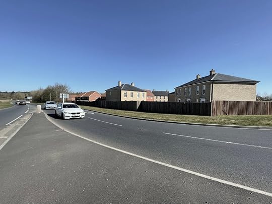 The new negative urban edge at Loddon: road, verge, fence, backs
Developers in such locations will certainly argue for lower-density detached housing and reduced green space, citing market demand. Yet evidence from Tackling Inequality in Housing Design Quality showed that with strategic public intervention, higher-density mixed-tenure models are viable. With 40–50% affordable housing planned across the new generation of new towns, this public role will be essential – not just to shift the dial of viability but also to secure design quality.
Landscape at the edge
Edge sites have two boundaries to design: the ‘old edge’ (between existing suburbs and the new development) and the ‘new edge’ (between new the settlement and countryside).
Residents along the old edge often resist nearby development and, if it proceeds, call for buffers and fences to ‘protect’ their neighbourhoods. This instinct must be resisted. A successful edge between old and new should be a permeable connective seam, not a barrier – connecting communities to encourage walkability and the sharing of facilities, but also to maintain access for established residents to the countryside.
The new edge, facing outward, should likewise be porous and landscape-led. Whether it proves permanent or not, it should function as a living transition – allowing movement, ecology, and views to flow. The design might be seen as the physical expression of a ‘contract’ between old, new, and future residents, setting out that change may occur, but this place will remain an intermediary between town and country in perpetuity.
The first Essex Design Guide captured this well over fifty years ago, distinguishing ‘new urban’ places (space defined by buildings) and ‘new rural’ one (space defined by landscape). Both are needed. A successful edge settlement should step from a dense urban core, through medium-density neighbourhoods, to a landscape-dominated fringe – avoiding the road-dominated, placeless sprawl that the Essex Design Guide characterised as ‘unsatisfactory suburbia’.
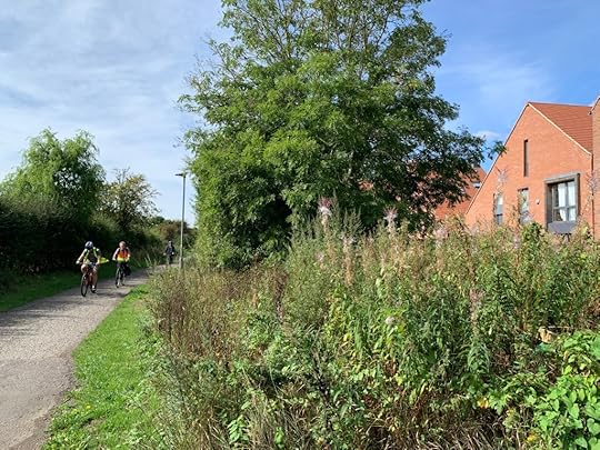 Derwenthorpe on the edge of York maintains a network of generous landscape connections from the countryside to the plentiful and varied green open spaces within the development
Stuff at the edge
Greenfield sites are never blank slates. They come with their own topography, ecology, and history – and often, a good deal of awkward ‘stuff’.
At Chase Park, remnants of an anti-aircraft battery and army encampment sit among rolling fields, hedgerows and two brooks. At Crews Hill, the stuff includes fragmented land holdings, a rich ecology of businesses, rows of pylons, the M25, and the Hertford Loop railway slicing through the site.
These features – some positive others negative – shouldn’t be ignored. Instead, they can become structuring elements – ecology parks along railways and brooks, solar arrays and vertical farms integrated into noise mitigation for motorways, the local economy assets consolidated and bolstered, and heritage features (built and natural) reinterpreted in public open space.
Of course, none of this will be easy, although the Government’s response to the Taskforce was helpful, setting out unequivocally: “We want exemplary development to be the norm, not the exception”. Achieving that will look very different in a city centre location to London’s green belt edge, or indeed the variety of other edge sites identified by the Taskforce.
We have long struggled to design positive, permeable, ecologically rich suburban schemes. Yet that is precisely what most of the Taskforce’s new towns will be: large-scale suburban extensions. To succeed, they must combine urban density with landscape richness and connection, and making the most of local assets – good and bad – already in place.
The new towns programme offers a once-in-a-generation opportunity to get suburban growth right. We should see it for what it is, and let’s hope we have the vision – and the courage – to deliver it.
Matthew Carmona
Professor of Planning & Urban Design
The Bartlett School of Planning, UCL


Matthew Carmona's Blog

- Matthew Carmona's profile
- 12 followers

