
The History Book Club discussion

This topic is about
Life on the Mississippi
AMERICAN HISTORY
>
GLOSSARY - LIFE ON THE MISSISSIPPI
date newest »
 A map of the Mississippi river and its tributaries:
 About the Mississippi River, intro text and link to full text:
The Mississippi River is the largest river system in North America. Flowing entirely in the United States, this river rises in western Minnesota and meanders slowly southwards for 2,530 miles (4,070 km) to the Mississippi River Delta at the Gulf of Mexico. With its many tributaries, the Mississippi's watershed drains all or parts of 31 U.S. states between the Rocky and Appalachian Mountains and even reaches into southern Canada. The Mississippi ranks fourth longest and tenth largest among the world's rivers.
For at least 10,000 years, Native Americans have lived along the Mississippi and its tributaries. Most were hunter-gatherers or herders, but some such as the Mound builders formed prolific agricultural societies. The arrival of Europeans in the 1500s forever changed the native way of life as first explorers, then settlers, ventured into the basin in increasing numbers. The river served first as barrier – forming borders for New Spain, New France, and the early United States – then as vital transportation artery and communications link. In the 19th century, during the height of Manifest Destiny, the Mississippi and several western tributaries, most notably the Missouri, formed pathways for pioneers partaking in the western expansion of the United States.
Formed from thick layers of this river's silt deposits, the Mississippi River Valley is one of the most fertile agricultural regions of the country and as a result came the rise of the river's storied steamboat era. During the American Civil War, the Mississippi's capture by Union forces marked a turning point towards victory because of this very importance as a route of trade and travel, not least to the Confederacy. Because of substantial growth of cities, and the larger ships and barges that have supplanted riverboats, the decades following the 1900s saw massive engineering works applied to the river system, such as the often in-combination construction of levees, locks and dams.
Since modern development of the basin began, the Mississippi has also seen its share of pollution and environmental problems – most notably large volumes of agricultural runoff, which has led to the Gulf of Mexico dead zone off the Delta. In recent years, the river has shown a steady shift towards the Atchafalaya River channel in the Delta; a course change would prove disastrous to seaports such as New Orleans. A system of dikes and gates has so far held the Mississippi at bay, but due to fluvial processes the shift becomes more likely each year.
http://en.wikipedia.org/wiki/Mississi...
 Mod
Mod
 Thanks for the map. On the very first page of my edition, it says that the Mississippi draws it water supply "from Delaware on the Atlantic seaboard..." Since I live in New Jersey, I knew this was not the case. Your map indicates that is incorrect. Do I have a typo in my book or was Mark Twain's information wrong? How accurate is his book?
Emily I do not know where Twain drew his information from. The map I posted above is from the wikipedia listing on the Mississippi River.
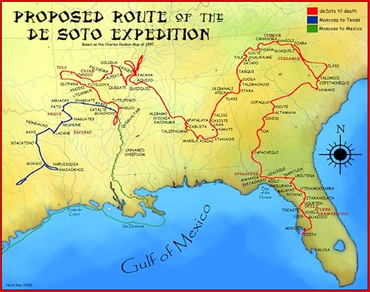
Excerpts of Hernando de Soto's expedition associated with the Mississippi River and link to the full history of him on wikipedia:
Thanks for the map. On the very first page of my edition, it says that the Mississippi draws it water supply "from Delaware on the Atlantic seaboard..." Since I live in New Jersey, I knew this was not the case. Your map indicates that is incorrect. Do I have a typo in my book or was Mark Twain's information wrong? How accurate is his book?
Emily I do not know where Twain drew his information from. The map I posted above is from the wikipedia listing on the Mississippi River.
Excerpts of Hernando de Soto's expedition associated with the Mississippi River and link to the full history of him on wikipedia:Hernando de Soto (c.1496/1497–1542) was a Spanish explorer and conquistador who, while leading the first European expedition deep into the territory of the modern-day United States, was the first European documented to have crossed the Mississippi River.
A vast undertaking, de Soto's North American expedition ranged throughout the southeastern United States searching for gold and a passage to China. De Soto died in 1542 on the banks of the Mississippi River in Arkansas or Louisiana.
http://en.wikipedia.org/wiki/Hernando...
map of the expedition:
 LaSalle's journey and links:
La Salle reassembled a party for another major expedition. In 1682 he departed from present-day Fort Wayne with 18 Indians and canoed down the Mississippi River. He named the Mississippi basin La Louisiane in honor of Louis XIV and claimed it for France. At what later became the site of Memphis, Tennessee, La Salle built the small Fort Prudhomme. On April 9, 1682, at the mouth of the Mississippi River near modern Venice, Louisiana, La Salle buried an engraved plate and a cross, claiming the territory for France.
In 1683, on his return voyage, La Salle established Fort Saint Louis of Illinois, at Starved Rock on the Illinois River, to replace Fort Crevecoeur. He appointed Tonti to command the fort while La Salle traveled to France for supplies. On July 24, 1684, La Salle departed France and returned to America with a large expedition designed to establish a French colony on the Gulf of Mexico, at the mouth of the Mississippi River. They had four ships and 300 colonists. The expedition was plagued by pirates, hostile Indians, and poor navigation. One ship was lost to pirates in the West Indies, a second sank in the inlets of Matagorda Bay, and a third ran aground there. They founded Fort Saint Louis, on Garcitas Creek in Victoria County, Texas. La Salle led a group eastward on foot on three occasions to try to locate the mouth of the Mississippi.
http://en.wikipedia.org/wiki/Ren%C3%A...
 Emily wrote: "Thanks for the map. On the very first page of my edition, it says that the Mississippi draws it water supply "from Delaware on the Atlantic seaboard..." Since I live in New Jersey, I knew this wa..."
I was wondering about that also. I grew up in Delaware and was pretty sure no water from there ended up in the Mississippi river.
I also noticed the Delaware reference in the book. I've done some digging around to find reference to it in other materials describing the Mississippi River tributary system but nothing specific mentions Delaware.
Most people have heard of the Western Continental Divide that separates the watersheds of the Atlantic and the Pacific Oceans. However, many don't know that there is an Eastern Continental Divide in the US that separates the water that flows into the Atlantic Ocean from the waters that flow into the Gulf of Mexico. That line follows the Appalachian Mountains. Any watershed east of the Appalachian Mountains flows into the Atlantic, while the watersheds west of the mountains and east of the Rockies flows into the Gulf. If you look at the map above, it clearly shows the eastern boundary of the Mississippi River watershed to be the Appalachian Mountains.I got the following info from Wikipedia: "The Eastern Continental Divide, in conjunction with other continental divides of North America, demarcates two watersheds of the Atlantic Ocean: the Gulf of Mexico watershed and the Atlantic Seaboard watershed. Prior to 1760, the divide represented the boundary between British and French colonial possessions in North America. The ECD runs south-southwest from the Eastern Triple Divide in Pennsylvania to the watershed of the Kissimmee River, which drains via the Lake Okeechobee and the Okeechobee Waterway to both the Gulf of Mexico and the Atlantic Ocean."
It is clear that Twain has given us incorrect information, either accidentally or deliberately. Delaware, New Jersey and Connecticut (where Twain lived) are entirely east of the Appalachian chain.
Emily wrote: "Most people have heard of the Western Continental Divide that separates the watersheds of the Atlantic and the Pacific Oceans. However, many don't know that there is an Eastern Continental Divide i..."That is interesting. You are right I have heard of the western Continental Divide but not the eastern one. I guess I am not the only one, sounds like Mark Twain hadn't heard of it either (lol). Makes sense when you think about it though. Thanks for clearing that up for me!
There are numerous references to the story of Huck Finn. Link to the book for those who are not familiar with the classic: by
by
 Mark Twain
 Kathy F wrote: "Emily wrote: "Thanks for the map. On the very first page of my edition, it says that the Mississippi draws it water supply "from Delaware on the Atlantic seaboard..." Since I live in New Jersey, ..."
He continues that same passage: "and from all the country between that and Idaho on the Pacific slope." I'm from the West and I say "barely". I simply thought that the historic border of Idaho had moved around and I forgot about it, but if you say that he was wrong about Delaware. . .
If you look at Alisa's map you can see the the Madison and Jefferson rivers' headwaters are in Wyoming. (Increase your browser's magnification to 400%.) When I was a kid on family vacation I stood on this cool part of the Continental Divide and saw some river or other run east on one side of the hill and west off the other. (Very, very cool let me tell you!) I can't remeber where that was but I'd lay large quantities of money on it not being in Idaho. Again using Alisa's map, I'd lean towards Northern Wyoming, or Central Colorado -- which even by Western standards of distance are not near Idaho.
I think that what we see here is a slight overstatement on Twain's part.
Shannon
Shannon wrote: "Kathy F wrote: "Emily wrote: "Thanks for the map. On the very first page of my edition, it says that the Mississippi draws it water supply "from Delaware on the Atlantic seaboard..." Since I live..."I'm not sure if Twain was exaggerating or just didn't know his facts. I'm inclined toward the former since there is a lot of "hyperbole" in his book so far.
One evening, I was driving my children after dark on Interstate 68 in Maryland. There was a sign for the Eastern Continental Divide (http://www.interstate68.com/) and immediately it began to rain! After about a mile, it just as abruptly stopped. Very eerie.
It was probably some combination of literary license and ill-defined borders, some of which have undoubtedly changed after he wrote the book. Still, I'd have to agree that Delaware and Idaho are a stretch. Which is one reason I added the map.
Delaware's borders have not moved for over 200 years. The only way that Delaware or the Delaware River could have been part of the Mississippi River watershed is if the Appalachian Mountains changed their location about the time that Twain wrote his book and then inexplicably moved back after it was published.
I was thinking more of what might have been considered Idaho territory but I appreciate your point.
Alisa wrote: "I was thinking more of what might have been considered Idaho territory but I appreciate your point."Idaho territory was founded in 1863 and included the modern states of Idaho, Monatana and Wyoming. In 1864 it ceded territory to Montana and what was called dakota territory, but looks alot like Wyoming. By 1868 the modern boundaries were in place. Idaho bacome a state in 1890 along with Wyoming.
The book was published in 1883.
Mod
Yes, Emily it probably is a stretch but we try to give the author the benefit of the doubt even though in this case he is a teller of tall tales. (smile)
Simran, good questions. Twain was a amn of many trades in his lifetime, some more successful than others. It was his time as a reporter that appeared to foster his writing career outside of reporting, and in his time he was in demand as a speaker. A lot of good and extensive information can be foundin the wikipedia link to his background, posted here:http://en.wikipedia.org/wiki/Mark_twain
Hope this helps.
Rendering of a keelboat that was popular before the steamboat era that was used to move people and goods along the Mississippi River.[image error]
Mod
http://civil.engr.siu.edu/301I_Ray/mi...
Interesting article, thanks for the addition Bentley. It states in rather graphic terms what all gets dumped into the river. Blech. It was, of course, a different kind of sendiment that ran in Twain's time before heavy industrialization.
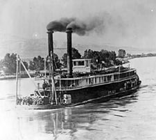
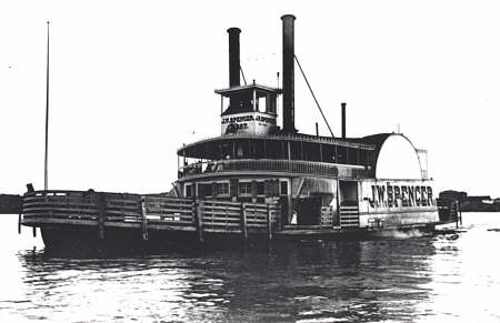
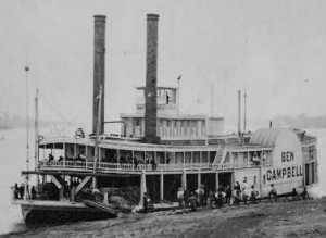
Images of steamboats from the time Twain was a pilot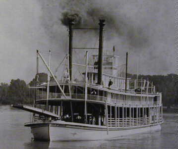
 Mod
Mod
I don't think it was that good then either (smile); but you are right.
True, although at least there were fewer people. Still, yuk.
Mod
This is what a flatbed might look like which hauled timber along the river. My edition does not have a timine so glad you found one. Glad the wiki link was helpful.
 Bentley wrote: "Emily wrote: "Delaware's borders have not moved for over 200 years. The only way that Delaware or the Delaware River could have been part of the Mississippi River watershed is if the Appalachian M..."
The version I'm reading (Oxford U Press, World's Classics 1990) has as its first endnote "Delaware: Twain repeats this curious mistake on p. 13, so this is no slip of the pen. 'The waters of Delaware are generally thought to empty into the Chesapeake Bay. The easternmost point of tribute to the Mississippi is the head-waters of the Allegheny River, near Olcan, New York."
Interesting Jim, thanks for that clarification. I don't have that note in my edition, appreciate you sharing it here. Any reference to how he gets Idaho out of this?
Jim, thanks for the info. Actually, the Delaware River does not flow into the Chesapeake Bay, but into Delaware Bay and then into the Atlantic Ocean. However, there is a canal built, called the Chesapeake and Delaware Canal that connects the Delaware Bay with the Chesapeake Bay. According to a Wikipedia article, the Delaware Bay is the second busiest waterway in the United States after the Mississippi River.http://en.wikipedia.org/wiki/Delaware...
I, also, would be interested in knowing anything about the Idaho question.
Alas: I can't see any mention of the Idaho issue in the endnotes.
 There are photos of Twain's journals and various other things relating to his life with the Mississippi:
 http://bancroft.berkeley.edu/Exhibits...
(Again - not quite sure what I'm doing.)
Becky, great resource and thanks for posting. Some good photos and journals there about Twain. Thanks!Posting to an external link as fan as long as it falls within our guidlines of no self promotion. The link you posted is well within that guideline and relates well to the overall topic being discussed here. Much appreciated and welcome, these threads are for exactly this - conversation about the book and related matters.
Thank you - and I have certainly enjoyed the various boat pictures you posted! Great stuff and so historical Americana.
Boiler explosionsIn the forty years to the mid-century mark, there were some 4,000 fatalities on the river due to boiler explosions. Some 500 vessels were wrecked by the peril. Early boilers were riveted of weak iron plate. Vessels at the time were not inspected, or insured. Passengers were on their own. Meanwhile, the explosions continued: the Teche in 1825, with sixty killed; the Ohio and the Macon in 1826; the Union and the Hornet in 1827; the Grampus in 1828; the Patriot and the Kenawa in 1829; the Car of Commerce and the Portsmouth in 1830; the Moselle"" in 1838.
Mark Twain noted a bad boiler explosion which occurred aboard the steamboat Pennsylvania in 1858. Among the injured passengers was Henry Clemens, his brother, whose skin had been badly scalded. Twain came to visit Henry in an improvised hospital. This is how he described the long painful death of his brother: “For forty-eight hours I labored at the bedside of my poor burned and bruised but uncomplaining brother...and then the star of my hope went out and left me in the gloom of despair...” On February 24, 1830, as the Helen McGregor prepared to pull away from the Memphis waterfront, the starboard boiler blew. The blast itself and flying debris killed a number of people, and about thirty others were scalded to death.
source: wikipedia
Construction of the vesselsVessels were made of wood—typically ranging in length from 80 to 140 feet (43 m) in length, 10 to 20 feet (6.1 m) wide, drawing only about one to two feet of water, and in fact it was commonly said that they could "navigate on a heavy dew." The boats had kingposts or internal masts to support hogchains, or iron trusses, which prevented the hull from sagging. A second deck was added, the Texas Deck, to provided cabins and passenger areas. All was built from wood. Stairs, galleys, parlors were also added. Often the boats became quite ornate with wood trim, velvet, plush chairs, gilt edging and other trimmings sometimes featured as per the owner's taste and pocketbook. Wood burning boilers were forward center to distribute weight. The engines were also amidships, or at the stern depending on if the vessel was a sternwheeler or sidewheeler. Two rudders were fitted to help steer the ship.
Vessels, on average, only lasted about five years as the wooden hulls would be breached, they were poorly maintained, fires and general wear and tear, and the common boiler explosion. Early trips of the river took three weeks to get to the Ohio River. Later, with better pilots, more powerful engines and boilers, removal of obstacles and experienced rivermen knowing where the sand bars were, the figure was reduced to 4 days. Collisions and snags were constant perils
Mississippi River CommissionThe Mississippi River Commission was established in 1879 to facilitate improvement of the Mississippi River from the Head of Passes near its mouth to its headwaters. The stated mission of the Commission was to:
Develop and implement plans to correct, permanently locate, and deepen the channel of the Mississippi River.
Improve and give safety and ease to the navigation thereof.
Prevent destructive floods.
Promote and facilitate commerce, trade, and the postal service.
For nearly a half century the MRC functioned as an executive body reporting directly to the Secretary of War. The Great Mississippi Flood of 1927 changed the mission of the MRC. The consequent Flood Control Act of 1928 created the Mississippi River and Tributaries Project (MR&T). The act assigned responsibility for developing and implementing the Mississippi River and Tributaries Project (MR&T) to the Mississippi River Commission. The MR&T project provides for:
Control of floods of the Mississippi River from Head of Passes to vicinity of Cape Girardeau, Missouri.
Control of floods of the tributaries and outlets of the Mississippi River as they are affected by its backwaters.
Improvement for navigation of the Mississippi River from Baton Rouge, Louisiana, to Cairo, Illinois. This includes improvements to certain harbors and improvement for navigation of Old and Atchafalaya Rivers from the Mississippi River to Morgan City, Louisiana.
Bank stabilization of the Mississippi River from the Head of Passes to Cairo, Illinois.
Preservation, restoration, and enhancement of environmental resources, including but not limited to measures for fish and wildlife, increased water supplies, recreation, cultural resources, and other related water resources development programs.
Semi-annual inspection trips to observe river conditions and facilitate coordination with local interests in implementation of the project.
The President of the Mississippi River Commission is its executive head. The mission is executed through the Mississippi Valley Division, U.S. Army Engineer Districts in St. Louis, Memphis, Vicksburg, and New Orleans.
source of the info above: wikipedia
read more at: http://www.mvd.usace.army.mil/mrc/his...
A few notes from wikipedia on Natchez at this period of time. read more at: http://en.wikipedia.org/wiki/Natchez,...Natchez was able to make a rapid economic comeback in the postwar years, with the resumption of much of the commercial shipping traffic on the Mississippi River. The cash crop was still cotton, but gang labor came to be largely replaced by Sharecropping. In addition to cotton, the development of local industries such as logging added to the exports through the city's wharf. In return, Natchez saw an influx of manufactured goods from Northern markets such as Cincinnati, Pittsburgh, and St. Louis.
The city's prominent place in Mississippi River commerce during the nineteenth century was expressed by the naming of nine steamboats plying the lower river between 1823 and 1918 which were named Natchez. Many were built for and commanded by the famous Captain, Thomas P. Leathers, whom Jefferson Davis had wanted to head the Confederate defense fleet on the Mississippi River. (This appointment never was concluded.) In 1885, the Anchor Line, known for its luxury steamboats operating between St. Louis and New Orleans, launched its "brag boat", the City of Natchez. This ship survived only a year before succumbing to a fire at Cairo, Illinois, on 28 December 1886. Since 1975, an excursion steamboat at New Orleans has also borne the name Natchez.
Such river commerce sustained the city's economic growth until just after the turn of the twentieth century, when steamboat traffic began to be replaced by the railroads. The city's economy declined over the course of the century, as did that of many Mississippi river towns. Tourism has helped compensate for the decline.
After the war and during Reconstruction, the world of domestic servants in Natchez changed somewhat in response to Emancipation and freedom. After the Civil War, most domestic servants continued to be black women, and often they were single mothers. Although they were poorly paid, they found domestic work provided an important source of income for family maintenance. White employers often continued the paternalism that characterized relations between slaveholders and slaves. They often preferred black workers to white servants. White men and women who did work as domestics generally held positions such as gardener or governess, while black servants worked as cooks, maids, and laundresses.
Natchez, Mississippi, is one of the many stops that Twain makes along his river journey when he returns in later years. He speaks briefly about the little southern town in his book. Here is some additional information about Natchez after the Civil War:Natchez was able to make a rapid economic comeback in the postwar years, with the resumption of much of the commercial shipping traffic on the Mississippi River. The cash crop was still cotton, but gang labor came to be largely replaced by Sharecropping. In addition to cotton, the development of local industries such as logging added to the exports through the city's wharf. In return, Natchez saw an influx of manufactured goods from Northern markets such as Cincinnati, Pittsburgh, and St. Louis.
The city's prominent place in Mississippi River commerce during the nineteenth century was expressed by the naming of nine steamboats plying the lower river between 1823 and 1918 which were named Natchez. Many were built for and commanded by the famous Captain, Thomas P. Leathers, whom Jefferson Davis had wanted to head the Confederate defense fleet on the Mississippi River. (This appointment never was concluded.) In 1885, the Anchor Line, known for its luxury steamboats operating between St. Louis and New Orleans, launched its "brag boat", the City of Natchez. This ship survived only a year before succumbing to a fire at Cairo, Illinois, on 28 December 1886. Since 1975, an excursion steamboat at New Orleans has also borne the name Natchez.
Such river commerce sustained the city's economic growth until just after the turn of the twentieth century, when steamboat traffic began to be replaced by the railroads. The city's economy declined over the course of the century, as did that of many Mississippi river towns. Tourism has helped compensate for the decline.
[image error]
Bridge over the Mississippi River at Natchez
source: http://en.wikipedia.org/wiki/Natchez,...
 I know this is late; but thank you all for the clarification on the Twain claim that the Mississippi river contains water from Delaware. I near went crazy looking for information.

The History Book Club
Books mentioned in this topic
The Adventures of Huckleberry Finn (other topics)Life on the Mississippi (other topics)
Authors mentioned in this topic
Mark Twain (other topics)Mark Twain (other topics)

This is a spoiler thread where links to helpful information regarding this book and its history may be posted. Please remember that we do not allow self promotion, ads or marketing.