Jeff Mitchell's Blog
November 24, 2025
Porcupine Rock Lookout and Don Watson Trail-State Game Lands 75
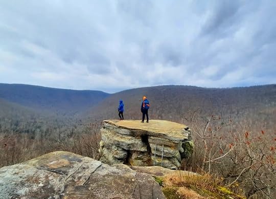 Porcupine Rock Lookout
Location: Near English Center, in SGL 75.
Parking: P1 is at about 41.444709, -77.276308 . P2 is only accessible when the gate is open during hunting seasons. It provides a much shorter hike to the lookout. When we hiked the loop, this road was in good shape.
Length: About 8 miles for the whole loop with out and back to the lookout.
Difficulty: This is a challenging hike with steep terrain in places.
Highlights: Superb view from Porcupine Rock. Hemlocks, mountain laurel, leaves off views from a ridge.
Blazes: The trails are blazed red. Even the road walk has red blazes.
Trail conditions: Variable. We hiked this in late November and found the whole loop navigable, but it may be more difficult in summer. The trails were blazed generally well, with some blazes far apart, but we were able to follow them. There were some areas of thick laurel, but again there was usually a way through, and we could see the next blaze with some patience. There were blowdowns and fallen branches on the trail; a treadway was not always apparent.
Other route: Using Lick Run Trail may be an option, but I do not know its condition.
Description: This hike is a hidden gem in the PA Wilds and has one of its better views. It is also an anomaly. Usually, game lands do not have blazed hiking trails with signs, but there is one here. And it is a worthwhile trail that could use more footsteps.
We decided to do the whole loop. The scenic highlight is the lookout, but I found the loop to be a fine hike. If you just want to see the vista, start from P2 if the gate is open, or maybe the Lick Run Trail.
From P1, we hiked counterclockwise. There is a trail sign saying the loop is 5 miles, but it is longer than that. A steep climb up a glen with a seasonal stream followed (A on map). It was blazed kind of well, but there were debris and little sign of a treadway. The climb steepened near the top. This is the steepest part of the hike. The trail leveled and turned turned right into hemlocks, and then, laurel. The laurel, overall, wasn’t that bad. There was a way through with no serious bushwhacking. My perspective may be skewed because I’ve been through some horrendous laurel. The blazes are there, but you will need some patience to see the next one is places. The trail then enters open hardwoods along a ridge with nice off leaf views. It becomes easier to follow and appears to use an old forest road.
Reach the first trail juncture with signs; veer left. Lick Run Trail is to the right and might be an alternate route. Go over a small hill and reach a second trail juncture with a sign for Don Watson Trail and an arrow to Bear Run Road (see photo below), which I guess is also Cemetery Road. You will return here to complete the loop, but go straight to the overlook.
Reach a third trail juncture, go left. Straight goes to the game lands boundary. Follow the spur trail to the lookout along a narrowing ridge. The trail follows a grassy ATV trail. Reach a small grassy clearing surrounded by laurel. Look for a trail going straight, or north. You can see a blaze down this trail. Avoid the trail to the left. We soon reached Porcupine Rock. I was impressed. It features 180 degree views of a wooded gorge with no sign of development, other than the road below. It would be a fine sunset hike. There is a giant rock pedestal that we reached via a small ladder. True to its name, porcupines live in the rocks and their droppings are on the ground. Spend some time at this beautiful place. The view is dramatic.
Retrace your steps to the loop (second trail juncture) and now turn right. Descend into a glen with hemlocks. Reach B on the map. Here, the trail goes through thickets of saplings and pickers. It was cut back when we hiked, but it can be an issue in the future. At the bottom, reach P2, and hike the road back to P1.
Put this hike on your list. I look forward to returning to see the fall colors.
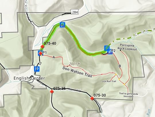 Trail is blazed red. Yellow dots are trail signs. There is a gate after P1, only open during hunting seasons. P1 and P2 are identified that way for this map and are not identified that way on the ground. Routes on this map are not gps tracks and are for general directional purposes, use at your own risk. Locations are approximate.
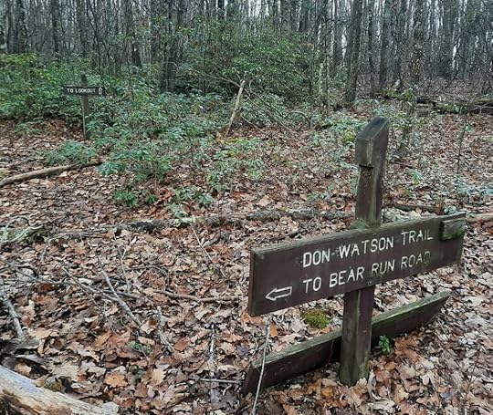 This is the trail junction where the spur trail leads to the lookout. This junction is above the glen marked B on the map.
View this post on Instagram
October 6, 2025
Hike the Frozen Run Gorge-Loyalsock State Forest
 Frozen Run Gorge Vista
Length: Varies greatly; this is an off trail hike. You can hike 5-10 miles depending on the features you want to see.
Trail conditions: No marked trails or signs, this is an off trail hike. There are some old logging roads and grades that can be used.
Difficulty: This is a challenging and difficult hike that should only be attempted by experienced hikers with good navigational skills. Terrain is rocky and steep with cliffs and ledges. You will also need to cross creeks without bridges (although there is one bridge). Do not hike here alone. Use all safety precautions.
Parking: Look for pull off parking roughly here: 41.502362, -77.008409 . Bodine Mountain Road was in very good shape when I was last on it, although it is narrow when going up the mountain. There may be gas trucks using the road. There were check stations at the bottom and top directing traffic, so you may be asked to wait for a truck to use the road.
When to hike: When the creeks are flowing well (due to all the falls and cascades), but do not attempt this hike in high water. Frozen Run becomes a ferocious whitewater river. Bodine Mountain Road is likely not accessible in winter.
Highlights: Stunning views, waterfalls, rapids, cascades, giant rocks, overhangs, caves, chasms, beautiful creeks.
Future: There is talk of a hiking trail system being established in the gorge.
Description: Frozen Run is a crown jewel of the Loyalsock State Forest, and even Pennsylvania. It is a place of incredible beauty. But there is a price. It requires off trail hiking and it is rugged. However, if you come here, it will be an experience you won’t forget.
Frozen Run is just different from other gorges in PA. The creeks are wild and rugged, filled with large, smooth boulders with rapids, cascades, and pools. There are waterfalls on the tributaries. There’s a glen with smooth bedrock and deep pools. There are giant rocks, cliffs, chasms, and overhangs on the top of the plateau. And there is the stunning Frozen Run Gorge Vista, looking straight down the gorge with the impressive Pickenville Cliffs. You can easily spend a day in this magnificent place.
This is a hike where you really need to choose your own route. You can stay on top and explore all the giant rocks. There are impressive rock formations and overhangs. One view is Windmill Vista; it’s not an amazing view as it looks across the top of the plateau to some windmills. A very cool chasm scramble is close by.
Frozen Run Gorge Vista is a must-see. There are other views on the escarpment, but you must punch through the laurel to see them.
I also recommend you explore Frozen Run and the side streams. If there is good flow, expect to see lots of falls and cascades. These creeks are so beautiful. There is one random wooden footbridge, which I call the Bridge to Nowhere.
Trip reports from April, 2016 and October, 2016.
This place is also described in Hiking the Endless Mountains.
Enjoy this special place!
 Blue dots are larger falls, cascades, or rapids. Brown lines or old forest grades or roads. Black dots are rock features or views. All locations are approximate. This is a rugged gorge, be careful.
 View this post on InstagramA post shared by Jeff Mitchell-Outdoors Author (@hiking_mitch)
View this post on InstagramA post shared by Jeff Mitchell-Outdoors Author (@hiking_mitch)
View this post on InstagramA post shared by Jeff Mitchell-Outdoors Author (@hiking_mitch)
September 11, 2025
Backpacking the Mosquito Creek Trail Loop-Quehanna Wild Area
 Sunset from Crawford Vista
Length: My route was about 20 miles.
Parking: At Beaver Run Dam, 41.261214, -78.258028
Difficulty: Easy to moderate
Trail conditions: Overall, they were good. You do need to keep an eye out for some turns.
Blazes: Most trails are yellow. Quehanna Trail is orange.
Choose your own route: I chose this route because I never hiked Mosquito Creek Trail or the cross-country ski trail. There are many other options you can take.
Highlights: Meadows, isolation, wild elk, creeks, views, diverse forests, wildflowers, large boulders, some good campsites, ferns.
Direction of description: Counterclockwise from Beaver Run Dam.
Description: This loop explores some lesser used trails in Quehanna. It makes for a relatively easy hike with some great scenery. It can also be a good option for beginning backpackers.
From the parking area, walk up the road you drove in on, turn left onto a yellow trail and hike through scenic pine forests with moss. Turn right onto the East Cross Connector (ECC) and cross the Quehanna Highway. Enjoy more pines and meadows. I turned right onto the Teaberry Trail to see two views and returned to the ECC. The trail went through laurel and came out on an old forest road. I then turned right onto the Cross Country Ski Trail. This trail was more brushy with laurel, but was still easy to hike. I crossed a meadow and reached a road. I turned left and then right onto Deible Road. This is a more rugged jeep road. Watch where the road turns left. The yellow trail leaves the road, continuing straight, and intercepts the Quehanna Trail (QT). Turn left, or straight on the QT.
The QT veers left into a fern and hardwood forest and then wraps around some large boulders. Reach a yellow trail to the left. There was no sign, but it is the Mosquito Creek Trail (MCT). Before following it, follow the QT a few hundred feet to Deible Run Vista and a campsite.
Now follow the MCT. It was a very nice trail, meandering through the woods and then following a jeep road. It turns left off the road and enters a scenic moss and spruce forest. Cross the Quehanna Highway and follow a jeep road among towering spruce and moss carpets. The MCT turns left and leaves the jeep road. Enter the woods with a small creek, hardwoods, ferns, and meadows. It was an enjoyable hike with an isolated feel. Cross mowed meadows and veer right onto a jeep road. Cross a creek with wetlands and continue on the jeep road. Watch for a left turn off the road. Return to the woods and hike above McNerney Run. The creek has boulders and cascades. Cross Mosquito Creek on a high bridge and a campsite.
Follow the Bridge Trail. I took a side trail up to Crawford Vista to camp and enjoy the sunset. I heard elk bugle at night. The loop continues on Bridge Trail, crossing vast meadows. I turned left onto the ECC with more meadows and views. A beautiful section. At the Beaver Run pond, I turned right, crossed the dam and followed the gated road back to the car.
Quehanna Wild Area is a backpacking wonderland. Get out and enjoy it!
 Purple highlight is my route; trails are not marked that way. Black dots are large boulders. Blue are cascades. C are campsite; some are small.
View this post on InstagramA post shared by Jeff Mitchell-Outdoors Author (@hiking_mitch)
View this post on InstagramA post shared by Jeff Mitchell-Outdoors Author (@hiking_mitch)
View this post on InstagramA post shared by Jeff Mitchell-Outdoors Author (@hiking_mitch)
August 16, 2025
Backpack the West Loyalsock Loop-Loyalsock State Forest
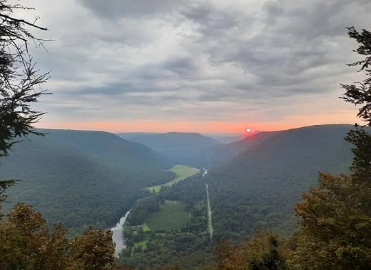 Sunrise from Smiths Knob
Length: About 20 miles
Parking: Dunwoody Road: 41.342693, -76.738965 . Little Bear Creek Road: 41.355676, -76.859364 . Little Bear Creek Road will probably be a more popular trailhead for most people.
Trail conditions: Good. The Loyalsock Trail (LT) is generally well marked and maintained. There are brushy areas. Other trails are also in good shape. There are two unblazed trails on this loop that were also in good shape. You should have good navigational and route finding skills for this loop. If you don’t want to hike the unblazed trails, you can bypass them on marked trails. However, I feel this route is the most scenic.
Difficulty: Moderate. Most of the terrain has gradual descents and inclines. Trails get steeper around Smiths Knob and Snake Run.
When I hiked it: August, 2025
Water: Usually plentiful. Loop crosses many streams.
Highlights: Scenic streams, creekside hiking, cascades, wildflowers, fine campsites, views, hemlocks, meadows, old CCC camp site, old LT route, pine and spruce forests.
Issues: Patches of nettle on Painter Run. Southern part of loop follows forest roads, which I found to be nice, easy hiking. One short section of forest road had some gas drilling traffic. This loop crosses many creeks, do not attempt in high water.
Direction of description: Counterclockwise from Dunwoody Rd. I parked there to camp at Smiths Knob.
Description: The Loyalsock State Forest has long been loved by hikers and backpackers due to its beauty. I’d been curious to see if a loop was possible along the western end of the famed Loyalsock Trail. I decided to check it out.
Overall, I was impressed and this loop exceeded my expectations.
From Dunwoody Road, I followed a horse or cross country ski trail down to near Hessler Branch. Look to your right to see a hunting cabin, and some spring pools in the woods. Look for an unblazed trail going down to the cabin. Take it. Pass the lodge and look for the trail enter the hemlocks. This unblazed trail is very scenic as it goes under hemlocks along Hessler Branch. When I hiked it, it was easy to follow. Reach a yellow trail, turn left and turn left on Grandad Trail at a sign. Hike up Grandad Trail along a tumbling creek, it’s a very nice trail. Level at the top with hemlocks and turn right on the LT. You will follow the LT most of the way to Little Bear Creek Road, below Smiths Knob.
Explore scenic forests with blueberry glades and ferns. Descend to beautiful Shingle Run with great camping and cascades under hemlocks. Hike over a ridge and descend to isolated Snake Run with another nice campsite. The creek here can be a trickle or dry in summer.
A steep climb follows out of Snake Run. The trail levels and then gradually descends. Reach a forest road (Red Ridge Road) and I turned right, leaving the LT. I followed the road and the LT soon rejoined. The LT left the road, passed a view of the Loyalsock Creek and made a steep climb to Smiths Knob with fantastic views. There is also a great, dry campsite here.
The LT descends steeply, levels, and passes another view. The long descent continues to Little Bear Creek Road and a trailhead. Turn left and hike up the road, a scenic walk with the creek, hemlocks, and hunting cabins. Turn left onto Painter Trail along Painter Run, a highlight. This scenic creek has mossy cascades, pools, wildflowers, and hemlocks. There’s even Canadian yew, a rare sight. There are also several creek crossings, so don’t attempt in high water. Patches of nettle are common in summer. Painter Run is very scenic. As you climb, the gorge narrows and the LT joins; veer right onto the LT. Painter Run has some small campsites, but they’re not very good. Climb to Red Ridge Road and turn right.
The road is a nice walk. It curves through the hemlock glen on Red Run and reaches the Sand Spring Camping area, a beautiful primitive car camping area and former CCC camp. Pine trees surround the sites. Hike down Sand Spring Road to Little Bear Creek Road and turn left; here you might encounter some gas drilling traffic. Climb and turn left onto Firetower Road. Veer right onto Miller Trail and descend. After a half mile or so, look for an obvious trail to the right with a wooden gate; this is the old LT route and it still has blazes (if you miss it, don’t worry, Miller Trail will take you to the same spot). Follow the Old LT down, passing odd wooden gates. At the bottom of the hill rejoin with Miller Trail and turn right.
Reach the current LT and turn left, crossing meadows with flowers, pine, and spruce. The LT turns left off the obvious old road, but continue straight. Complete the loop and continue up to the parking area on Dunwoody Road.
Get out there!!
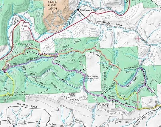 Route is highlighted purple; not blazed that way on the ground. C=campsites; V=vistas; P=parking. Dotted trails (other than Miller Trail or Red Run Rd) are the unblazed trails. Old LT still has faded LT blazes.
View this post on InstagramA post shared by Jeff Mitchell-Outdoors Author (@hiking_mitch)
View this post on InstagramA post shared by Jeff Mitchell-Outdoors Author (@hiking_mitch)
View this post on InstagramA post shared by Jeff Mitchell-Outdoors Author (@hiking_mitch)
View this post on InstagramA post shared by Jeff Mitchell-Outdoors Author (@hiking_mitch)
August 5, 2025
Hike the View and Lakes Loop-SGL 57
 A beautiful view on the loop
Length: 8 miles
Direction of description: counterclockwise
Parking: Pull off lot at Bowmans Marsh. 41.359575, -76.235278 Not maintained in winter.
Highlights: View, isolation, large rocks, streams, lakes and ponds, spruce forest, beaver dams and pond, meadows, seasonal wildflowers.
Trail conditions: This loop has unblazed, unmarked trails. Some trails can be faint but are usually followable. Only experienced hikers with good navigational skills should attempt. Trails can be overgrown in summer; if you are unfamiliar with this area, it is best to hike in fall to mid spring when the vegetation dies back. Some trails are shown on the Gaia app. I believe these trails were first made by mountain bikers.
Terrain: Moderate to easy. There are some gradual climbs and descents. Views are at the edge of a cliff. Trail is near steep slopes at times.
White Gold Loop: This hike was part of the White Gold Loop, described in my book Hiking the Endless Mountains. This was a phenomenal hiking loop. Sadly, the forest between Bean and Wolf Runs was logged, destroying the trail in that area and essentially severing the loop.
Description: This is a beautiful and fairly easy to moderate loop in SGL 57. However, these trails are unblazed. You need to keep an eye out for trails and trail junctures. From the parking area, hike down the road, enjoy views of Bowmans Marsh and turn left onto Beech Lake Road; hike around the gate. Follow the road up a small hill and look for a faint trail to the right, take it. Explore woodlands and fern glades. Reach the edge of the plateau and enjoy a fine view over the valleys and plateaus. There is no sign of development. Hike along the edge of the plateau with large rocks below. Descend to a lower bench and see large rocks above to the left. Descend to a road and turn left.
Hike to Bean Run and follow a trail up it. Watch for a trail to the right; take it and descend and cross Bean Run. Hike along this scenic stream with large rocks and ledges. There is also some spruce. Watch for a trail to the left that crosses Bean Run. Take it. Reach a T, turn right and hike up into a scenic, isolated valley with beaver dams, meadows, and spruce forests. Some of the spruce are quite tall. It is a beautiful section of the hike.
Gradually ascend into forests and reach a game commission road. Across the road is a large, scenic pond, one of four ponds or lakes on this hike. Turn left on the road and enjoy another view of a pond below the trail. Cross a swale and look for a trail to the right. Take it and hike down to sublime Beech Lake. Enjoy the views of this special spot. The trail moves from the lake and then returns to the other end with more views. Follow the grassy trail to Beech Run Road, completing the loop. Return to your car.
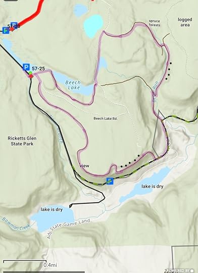 Purple highlight is my route. Brown trails are unmarked and can be faint. Black dots are large rocks. Locations are approximate, this is not a GPS track, accuracy not guaranteed, use at your own risk.
 View this post on InstagramA post shared by Jeff Mitchell-Outdoors Author (@hiking_mitch)
July 1, 2025
Backpacking the Laurel Highlands Hiking Trail
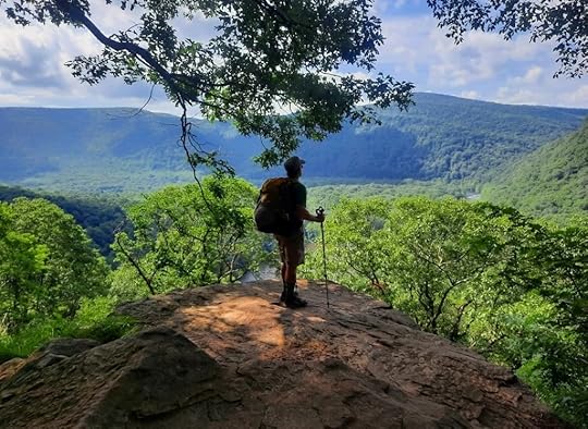 A view in Ohiopyle State Park
Length: 70 mile linear trail from Seward, PA to Ohiopyle State Park
Time of my hike: Late June, 2025
Blazes: Yellow. Side trails are blue.
Governing office: Laurel Ridge State Park
The state park offers a quality map with mileage, elevation profile, and parking areas.
Parking: The trail has well-developed parking areas and trailheads at most major road crossings. Seward parking area is at about 40.408911, -79.005835 . Ohiopyle is at about 39.872430, -79.494002 . There is a registration kiosk at both of those trailheads.
Trail conditions: Overall, pretty good. Trail was easy to follow. There are brushy sections, and others were mowed. There are some wet and muddy areas. Most trail junctures have signs and the trail has small concrete mile markers.
Camping: Camping is restricted to the shelter areas, which require reservations.
Shelters: There are eight shelter areas, each with five shelters, pit toilets, tenting areas, fire rings, bear poles to hang food, and garbage receptacles. Shelters have a fireplace and are not huge; they can hold four people. Cut firewood may also be available. By backpacking standards, the LHHT is a full-service trail.
Reservations: This trail is unique in that you must make reservations to camp at the shelters or tent sites. When making your itinerary, select all your dates and sites and make one reservation, do not make a separate reservation for each night. This will save you money with the reservation fees. Website for reservations.
Water: Generally plentiful, but the northern 20ish miles can be dry depending on conditions. Creeks and water become more common as you head south. There is a water pump at each shelter area (except Grindle Ridge, which was broken at the time of my hike). However, it can be a challenge to operate and fill your water bottles using the pump by yourself. Route 31 shelter area’s pump had iron in the water. You need to filter water from all pumps. There is also a spigot on the trail near Seven Springs with potable water, which I’m sure is not operational in winter. There is a creek south of Seven Springs that is contaminated (Blue Hole Creek, I believe) and should not be drank from, even if filtered. There were signs on my hike.
Amenities: Besides the shelters, the trail goes through Seven Springs and there was a sign telling hikers about a restaurant and lodge, so I presume those are things hikers could utilize.
Resupply: There is one store near the trail, and near the mid-point. Highlands Market has food and I heard may even accept resupply boxes. Backpackers should try to support local businesses, as they will then be more likely to support trails.
Difficulty: Moderate to challenging.
Terrain: You’d think a ridgetop trail would be easy, but the LHHT is not quite that. It has sneaky elevation gain and loss with hilly terrain. There are also long cruisey sections. The section through Ohiopyle State Park is the most challenging and the trail does get steep.
What direction should you go? I think there is no question you should go north to south. The climb out of Seward is more forgiving than the one out of Ohiopyle. You save the best scenery for the end. And you get to end your hike in beautiful Ohiopyle.
Forests: Primarily open hardwoods with ferns and laurel. Forests become more diverse as you head south with some areas of hemlocks and rhododendrons.
Bridges! I never hiked a trail with so many footbridges. Almost any creek, large, small, or even a ditch, had a wooden footbridge. Some were rather large and impressive. I’d even call the bridges a feature of the trail.
When to hike: Mid June for mountain laurel blooms. May to early June for wildflowers. October for fall colors. If you’re up for the challenge, the shelters make this trail a good winter hike.
Best section: Don’t want to hike the whole thing? I’d say the southern 32 miles, from Route 31 to Ohiopyle has the best and most diverse scenery.
Highlights: A few views, rock formations, giant boulders, rock grottos and mazes, scenic streams, good isolation in parts of the trail, a pond, small cascades and falls. Shelter areas and amenities as discussed above. Bridge over the turnpike. Fern glades. The rock features, beginning south of PA 271 and becoming more common in the south, might be the finest highlights of the trail. Best views are in Ohiopyle State Park.
Issues: Some shelter areas have road noise, few views for a trail this long, no sizeable waterfalls. Trail has some pointless ups and downs. Few creeks in the northern part of the trail. Some areas have nettle in the summer.
Brief Description: The Laurel Highlands Hiking Trail (LHHT) is the most famous backpacking trail in western Pennsylvania. It is unique in that it offers a lot of amenities and also requires reservations for camping. It definitely holds a special place among hikers in the western part of the state.
We went from Seward to Ohiopyle. The climb from Seward was long but not too hard. We went into some rhododendron tunnels, had a view at a powerline and another over Johnstown. The trail became cruisey with hardwoods and fern meadows. South of PA 271, we saw the first rock mazes, which were a highlight. They seemed to appear suddenly on the trail. The terrain became more hilly with small stream valleys.
The huge rock face of Beam Rocks appeared through the trees and we took the side trail to the top to enjoy the view. Hiking over the turnpike was a cool experience, and the trail became hillier to PA 31. Hiking the ski slopes at Seven Springs offered fine views and reminded me of hiking across ski resorts on the Colorado and Long Trails. Seven Springs seems to be hiker friendly. We missed Lake Tahoe, a ridgetop lake just off trail.
After some hills, the trail became very cruisey after Grindle Ridge Shelter Area. There are two fine views from cliffs, looking west. These are the second-best views on trail. Lower hills return and the trail passes a serene, isolated pond. The scenery picked up with beautiful streams, hemlock and pine forests, and boulder cascades. As we hiked through State Game Lands 111, there were many boulders, ledges, and rock grottos. Springs trickled and cascaded from the mossy rocks. It was very scenic and a highlight of the trail.
There was a very steep descent to the Ohiopyle Shelter Area, possibly the most scenic and isolated. The shelters are in a gorge above a tumbling creek. The trail through the state park was more rugged, with steeper climbs and descents, and several creek crossings on wooden plank bridges. The LHHT then ends with a bang–superb views over the Youghiogheny River with mountains towering in the distance. The trail descended and ended in Ohiopyle.
For our hike, we wanted to end at Ohiopyle Falls. So, we hiked to the falls, making that our southern terminus.
Ohiopyle State Park is an amazing place that you should explore. And the town has restaurants and cafes, making it perfect for an end-of-hike celebration.
Overall, the LHHT was a great hike. It was nice to return and thruhike it. If you haven’t backpacked it yet, get out there!!
View this post on InstagramA post shared by Jeff Mitchell-Outdoors Author (@hiking_mitch)
View this post on InstagramA post shared by Jeff Mitchell-Outdoors Author (@hiking_mitch)
View this post on InstagramA post shared by Jeff Mitchell-Outdoors Author (@hiking_mitch)
View this post on InstagramA post shared by Jeff Mitchell-Outdoors Author (@hiking_mitch)
June 16, 2025
Hike the Dry Run Gorge Loop-Loyalsock State Forest
 Tallest falls on Dutters Run, off trail
Parking: At ranger station 41.420704, -76.704171
Length: About 12 miles, varies depending on route taken.
Trail blazes: Mostly yellow, Loyalsock Trail (LT) is yellow/red.
Trail conditions: Pretty good. There are brushy areas, and an off trail section. Expect wet areas and mud.
Difficulty: Moderate to difficult. Off trail hike along Dutters Run is challenging, you can avoid by taking Dutters Trail or the LT.
Issues: Do not attempt in high water, there are many creek crossings on Dutters Run and one on Dry Run.
Highlights: High Knob Overlook, many waterfalls, gorges, cascades, rock outcrops, mountain top pond.
Direction of description: Counter clockwise from
Description: Dry Run Gorge is a gem in the Loyalsock State Forest. It has many waterfalls, cascades, and scenic creeks. There is also a network of trails you can follow to make a loop around the gorge. I think it is one of the most scenic in the Loyalsock and is rarely hiked. The east end of the loop has several loop options. Plus, if you don’t mind off trail hiking, there are other scenic spots to check out. This can also be a great overnight backpacking loop.
From the ranger station, hike the road toward PA 87, pass the cabin, and turn left onto the Old House Trail. Cross Dry Run without a bridge and enter a scenic pine forest. Watch for Stony Run Trail on the right, it is yellow. This trail is well blazed, but the treadway can be faint. Enter a gorge of small Stony Run and climb on an old grade. It’s a nice trail that needs more hikers. Enter an area of pine, hemlock, and laurel. The trail tunnels through the laurel, which had been cut back. The forest opens with ferns. Descend to the red bridle trail and turn right. Reach Dutters Trail on the left. Here you have three options on the east end of the loop: You can hike Dutters and Old Bark Trail, or follow the LT only, or follow the LT and then go off trail along Dutters Run to Dry Run Road and then follow Old Bark Trail. We took the final option as I think it’s the most scenic, and the most difficult. Choose whatever is best for you.
Turn left onto the LT and descend to scenic Dutters Run. It’s a winding, wooded gorge with several falls and cascades, and many creek crossings. The tallest falls is about 12 feet tall. Where the LT climbed away from Dutters Run, we just went off trail downstream. The terrain is rugged, and there are four more waterfalls. It is very beautiful. Be careful. There wasn’t much stinging nettle. The tallest falls might be 25 feet. There are ledges and cliffs. It gets steep getting around the bottom falls. Of course, it is best to climb up creeks, but this is just the way we went. Reach Dry Run Road, turn left and see beautiful Dry Run Falls. Take Old Bark Trail; just off trail is the very unique Old Bark Falls in a rock grotto. The Old Bark Trail gets wet towards the top and turn left onto the LT. Climb to High Knob Road, turn left and hike to High Knob Overlook. Descend steeply on the High Knob Trail and hike through beautiful woodlands. Turn right at Jackson Trail to see a sublime mountain top pond in a deep pine and hemlock forest, a favorite spot. Return to High Knob Trail and descend back to your car.
If you like to venture off trail, there are other things to see. Above Old Bark Run are huge rock shelters. High Knob Falls is surprisingly tall, maybe 25 feet over several steps, and if flowing well is an impressive sight. There are giant rocks and a view above Stony Run, as well as above High Knob Trail, near the pond. Andrea Falls is just off the road and is a great falls when flowing.
This loop is described in Hiking the Endless Mountains. Get out there!
Other places to see in and around Dry Run Gorge:
 Purple highlight is what I think is the most scenic route; choose your own route. Black dots are giant rocks, ledges, overhangs. Blue dots are falls and cascades. Red/yellow trail is the LT. Red trails is the bridle trail. Locations are approximate.
View this post on InstagramA post shared by Jeff Mitchell-Outdoors Author (@hiking_mitch)
View this post on InstagramA post shared by Jeff Mitchell-Outdoors Author (@hiking_mitch)
View this post on InstagramA post shared by Jeff Mitchell-Outdoors Author (@hiking_mitch)
View this post on InstagramA post shared by Jeff Mitchell-Outdoors Author (@hiking_mitch)
June 13, 2025
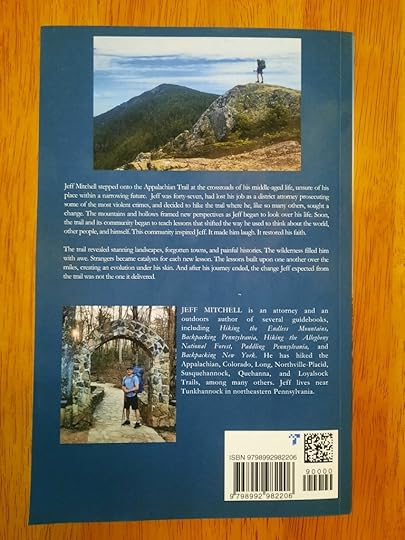
My New Book: Lessons Beyond the Horizon

Lessons Beyond the Horizon: A midlife education on the Appalachian Trail on Amazon.
Lessons Beyond the Horizon is about my 2022 thru-hike of the Appalachian Trail. It is my sixth book and first memoir.
Lessons Beyond the Horizon is different from other trail memoirs. It’s a coming-of-age story of someone who has lived over half of his life. It not only describes my personal journey but also focuses on the people I met along the way. Other thru-hikers, trail angels, section hikers, local residents, and people on their second, third, or fourth thru-hike attempts taught lessons, lessons that would build upon each other as I traveled north. Lessons also came from the natural beauty and history along the trail. These lessons varied from the personal–insecurity, aging, loss, and empathy–to larger societal issues, such as family dynamics, war, race, crime, gender, economic, environmental, and even life itself. As the miles passed, the trail became a common thread, representing the interconnection of these lessons. This book does not judge others. Rather, with brutal honesty, I realized the beliefs, assumptions, and stereotypes I had long held were in need of a second look. And after my hike was over, these lessons delivered a simple, humble change I never quite expected.
Lessons Beyond the Horizon will make you laugh and cry. It is inspiring and sobering. This book is thoughtful, vulnerable, and fearless. It will challenge you to look and feel beyond yourself. Its words will paint the Appalachian Trail’s breathtaking landscapes within your mind. This book reveals our spirit to always try to be a little bit better.
And now it’s time to take that next step…
June 10, 2025
Backpacking the Green Monster Trail (East Loop): Tioga State Forest
 Cascades on Straight Run
Length: About 16 miles
Parking: pull off at about 41.789883, -77.403146
Blazes: yellow, but are often faded and infrequent.
Trail conditions: The trails are in pretty good shape and are generally easy to follow. Most trail junctures have signs, but you do need to keep an eye out for turns.
Highlights: Scenic streams with cascades and small falls, hemlock gorges, mountain laurel blooms.
Issues: Stream crossings in high water. Need to keep an eye out for turns. Extensive logged area along Plantation Trail. Drill pad.
Difficulty: Moderate with some steep slopes. Similar to the Susquehannock Trail.
Direction of description: Loop is described counterclockwise.
Description: The Green Monster Trail is a 30+ mile loop that is beloved by trail runners and hosts a trail race in October. In March, I hiked the west loop and I returned to hike the east. The east loop may be the more popular of the two.
From the parking area, follow the Straight Run Trail and veer right onto the Deer Trail. Reach a road; do not follow the grassy grade behind a gate (Point A). The trail is a hundred feet or so to the right, just down the road. Climb up the Deer Trail, which levels off for a bit and then climbs more steeply. The woods are scenic. The top levels off and reaches a road. Across the road is Horse Lane Trail (if I remember correctly), this might be a better bypass around a gas well pad that you will soon cross, but I did not hike it.
The loop turns right on the road and then veers right into the woods. The trail goes along a giant drill pad and then returns to the woods with laurel. Turn left at a trail juncture and descend into a glen. An obvious trail joins from the left, this might be the other end of the Horse Lane Trail bypass. Descend the glen with cascades on your left. Reach a road and turn left. Turn right on Canada Run Road and then turn right onto Oil Well Hollow Trail. This is a highlight with a scenic gorge. There are hemlock and pine trees. As you hike, you can look down on the tumbling creek below. I skipped Bark Slide and Lost Trails as I didn’t see the point. The hike along the creek was probably much more scenic anyways. The climb steepened with cascades, leveled, crossed a road, and then I descended Carpenter Trail. Here, there was a pretty glen with small cascades. I reached the bottom, crossed a creek, and reached Spoor Hollow Road. Turn left and walk up the road.
Reach Stinger Trail. Here you have a decision. I recommend you skip Stinger and Plantation Trails. Stinger is quite steep, but that’s not the problem. When you reach the top, Plantation Trail passes extensive areas that have been logged. The trail was in good shape, but on one side you have clearcuts, and the other are no trespassing signs. Not exactly the most scenic hiking. Hiking Spoor Hollow Road might be the better option.
Things improve with the Jim Close Trail as it winds through scenic woodlands and along hemlocks with potential camping. Hike down a glen with pine and hemlocks, cross a road, and follow Birch Still Trail down into glens with cascading creeks, another fine spot. Climb to the top of the plateau. Reach Broad Ridge Trail and make a steep, eroded descent with loose gravel the trail runners call Frankenstein’s Forehead.
Turn left onto Left Straight Run Trail. This is a highlight, a sublime creekside hike with an assortment of small falls and cascades. It’s beautiful. There are also several water crossings, so expect wet feet and avoid in high water. Sidestreams tumble down with waterfalls. There is potential camping in places. The scenery improves as you head downstream with some larger falls and bedrock grottos. Complete the loop and retrace your steps.
I enjoyed this loop and suspect it would be even better with the two possible bypasses. It’s a fun, scenic hike with some challenge. Overall, I think the Green Monster Trail-West Loop is a better and more beautiful loop, but this one is worth doing as well.
 Yellow highlight is my route. Blue highlight is a possible bypass around a drill pad, but I did not hike it. Red highlight is a bypass on Spoor Hollow Rd. Blue dots are cascades and small falls. PC is potential camping. Locations are approximate.
 View this post on InstagramA post shared by Jeff Mitchell-Outdoors Author (@hiking_mitch)
View this post on InstagramA post shared by Jeff Mitchell-Outdoors Author (@hiking_mitch)
June 5, 2025
Gear Review: Gossamer Gear Kumo 36 Backpack
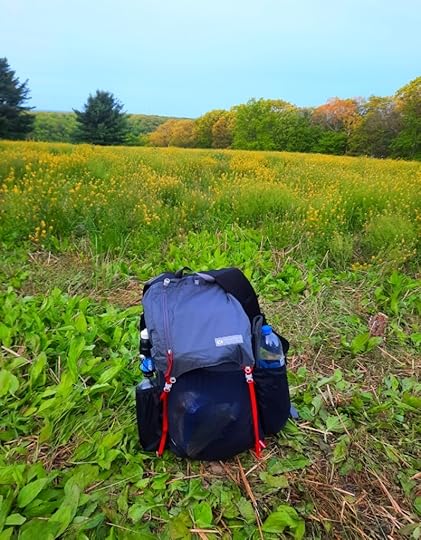
Specs: See the Gossamer Gear website. My model was last year’s but I presume the specs are basically the same. The Kumo 36 is a frameless backpack.
Unbiased: I paid for my pack and have received no incentive for this review.
Things I like: Very lightweight, comfortable shoulder straps, stretchy mesh pockets on the shoulder straps, large stretchy front mesh pocket, removable hip belt (which has pockets), side pockets can hold two one-liter water bottles, whistle on sternum strap, you can store your sleeping pad in the back of the pack. The top zip pocket is good for small items.
Things I don’t care for: I don’t care for the sliding sternum strap, I wish it could be locked in position.
Experience: I’ve backpacked about 100 miles with this pack.
Would I recommend this pack? Absolutely, if you’re looking to transition into lightweight backpacking.
Review: Like many backpackers, my gear has decreased in weight and volume over the years. As a result, my backpacks have also become more lightweight–from the REI Flash to a Durston Kakwa. A year or so ago, I decided to try a frameless backpack. I was intrigued by their simplicity, incredible light weight, and durability. Most of all, I wanted to see what it was like to hike without a hip belt.
I began my frameless journey with the Desolo Tallac 35. I liked the pack and it has some great features, but its shoulder straps weren’t comfortable enough for me–a critical requirement in frameless packs. Nor could I reach the water bottle in the side pocket, another important factor.
Gossamer Gear had a big sale for the Kumo 36; the reviews praised its comfortable shoulder straps, so I got one.
I’ve used the Kumo 36 several times now and I’m impressed. It carries up to 20 lbs quite comfortably. The shoulder straps are very comfortable and wide, dispersing the weight over my shoulders. I like to keep my water bottles in the shoulder strap pockets; this helps counterbalance the weight inside the pack. This pack is quite voluminous and is very light. The back mesh pocket, despite being cut at an angle, can hold a lot of gear. The pack seems well made and I have had no issues so far (I even went bushwhacking on an overgrown trail and the pack was fine). Sometimes, my upper mid back gets sore after several hours of hiking. That’s usually because the pack is hanging a touch too low. I tighten the shoulder straps a little and I’m fine. I like the pack’s low profile, especially when hiking through brush or under fallen trees.
This is a very simple pack, with all the things you need and nothing you don’t. If your kit is lightweight and dialed in, the Kumo 36 might be perfect for you. Without the hip belt, it is one of the lightest frameless packs on the market.
Like any frameless pack, the Kumo 36 can comfortably handle only so much weight. I’ve had it near 20 pounds and was fine.
Another reason why I got a frameless pack is that I really enjoy hiking without a hip belt. I feel cooler and have the freedom to walk and move without restriction. There is less sweat, and less abrasion or rubbing on my skin. The lack of a frame makes the pack hug closer to my body, ideal for scrambling or moving around blowdowns or other obstacles.
The Kumo 36 is not waterproof, which is fine with me. A trash compactor or nylofume bag quickly solves that issue.
In the crowded, and at times expensive, frameless backpack market, the Kumo 36 is easily considered a best buy.
I look to many more miles with the Kumo 36 and hope to try some longer trails with it.
 I trimmed my foam sleeping pad and use it to provide structure to the pack. The eggshell pad also ventilates my back. This feature also gives me a space-saving way to store my pad.
Jeff Mitchell's Blog
- Jeff Mitchell's profile
- 3 followers


