The Saigon River
An interlaced system of rivers, streams, and canals is one of the most distinctive aspects of Southern Vietnam or the Mekong Delta, which is both a benefit and a disadvantage of this region. Economic benefits from improving inland water transit may be the most advantageous benefit. In this regard, we may have to highlight the Saigon River, which has played an essential part in assisting Ho Chi Minh City (previously Sai Gon) in becoming the Pearl of the Far East, and is today a popular tourist attraction not to be missed by visitors to Ho Chi Minh City.
For those who have lived in Ho Chi Minh City for a long time, the Saigon River is regarded as a historic witness of the city, having observed the city's progress from the past to the present, bringing benefits to the city and its population, and beautifying the city to aid tourism development. In particular, it was from this river that Uncle Ho set off in the ship Admiral Latouche-Tréville in 1911 in search of a new means to free the country. Now we'll go explore this river and provide you with useful information for your upcoming visit to Ho Chi Minh City.
Where is the Saigon River Located?The headwaters of the Saigon River is in Binh Phuoc province's Hon Quan district (a province in Southeast Region in Vietnam). Before reaching the East Sea, it passes through three Vietnamese provinces: Tay Ninh, Binh Duong, and Ho Chi Minh City. It also serves as a dividing line between Binh Duong and Ho Chi Minh City.
Saigon River unites with Dong Nai River to form Nha Be River, which then divides into two river branches named Long Tau and Soai Rap before flowing to the sea through Can Gio Gate in Nha Be District, a suburb district of Ho Chi Minh City.
What is the Length of the Saigon River?From upstream to the Can Gio Gate, the Saigon River is 256 kilometers long, with an 80-kilometer part running through Ho Chi Minh City. According to maps, the river is located in the north of the city and flows approximately parallel to its length, forming a natural border with Binh Duong Province. Because of this characteristic, the Saigon River was formerly an essential conduit connecting two ends of the city when transportation was not as convenient as it is now.
What is the Depth of the Saigon River?The Saigon River's deepest section in Ho Chi Minh City is around 20 meters deep, with a width ranging from 225 meters to 370 meters. It is appropriate for small ships, boats, and yachts to operate because of its depth. The Saigon River was once used by the French colonists as the principal conduit for transhipping exploited natural resources from Southern Vietnam to French large ships in the East Sea through barges or small ships.
History of Saigon RiverSaigon River has always played an important role in the development of Ho Chi Minh City throughout history, or to put it another way, Saigon River is a constant companion to the city.
In the seventeenth century, when Ho Chi Minh City was just a little area in southern Vietnam named Gia Dinh, the only way to get there was to sail up the Saigon River. The Vietnamese government — the Nguyen Dynasty – decided to open and develop trade at this time. Due to the intertwined system of rivers and its ideal location near the sea, Gia Dinh quickly became one of Vietnam's principal commerce ports. From other provinces, the main method to Gia Dinh is to sail through Can Gio Gate to the Nha Be River, then turn right into the Saigon River to reach Gia Dinh.
The peak period of Saigon was from the eighteenth century to the first half of the twentieth century, and the function of the Saigon River grew in importance as a result. Saigon became the first commerce port in the Far East under the hands of the French colonists. Hundreds of ships from China, Malaysia, the Netherlands, and Portugal docked in Saigon every day to load up on Vietnamese agriculture and silks. The French colonists also established Nha Rong Port on the Saigon River, which became an important halt on the trade routes from Europe to Asia.
The elders in Ho Chi Minh City still remembered the opulent pictures of Saigon from the past. It is for this reason that Saigon is known as "The Pearl of the Far East."
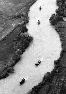
Saigon River HighlightsThe Saigon River flows peacefully from above, with several twisting parts that resemble a delicate scarf. Because the river is rich in alluvial, the water's primary color is red; nevertheless, the color can change according to the sky and sun. On sunny days, the sky is blue, and clouds can be seen reflected in the river.
Although roads and transportation have advanced significantly in recent years, residents can still travel between districts by boat because the Saigon River runs through nearly all of Ho Chi Minh City's districts. As a result, travelers may see the entire city by floating a boat along the Saigon River.
Not only does the Saigon River run through the city, but it also connects Ho Chi Minh City to other provinces and tourist attractions such as the Cu Chi tunnels, a well-known historical landmark in the city's suburbs. Alternatively, you can sail along the Saigon River to the Mekong Delta, where you can explore regions in Vietnam's south pole. Regardless of where you may find yourself, it can easily be said that the Saigon River is a remarkable river that truly is teeming with history and natural beauty.