Backpacking the Bucktail Loop-Elk State Forest
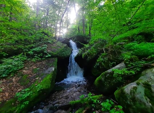
 Lick Island Falls
Length: About 23 miles (length varies based upon route taken. I do not recommend hiking Phins Trail, like I did. And many hikers may skip walking Ridge Road to see the vistas, and will hike the Bucktail Path (BP) instead.)
Parking: Space for 2 or 3 cars at the Bucktail Path. At approximately 41.418678, -78.037723
Highlights: This is a very scenic and diverse loop. Vistas, waterfalls, cascades, large boulders, meadows, extensive fern glades, blueberries, scenic streams, gorges, good isolation.
Trail blazes: BP is orange, other side trails are yellow.
Trail conditions: Overall, pretty good. The trails are blazed well and usually have a treadway. Some sections are brushy and have little treadway. Many trail junctures have signs. Navigation was fairly easy. The only issue is the Phins Trail. It was overgrown and basically a bushwhack with few blazes. If the Phins Trail gets cleared and receives fresh blazes, that would be the preferred route.
Trail issues: Nettle may be an occasional issue. Stream crossings in high water. Condition of the Phins Trail.
Mandatory trail tradition: Stop into the Lakeside Store on your hike for a quick resupply or ice cream. The people there were friendly. Support the locals. If they see hikers supporting their business, they will likely support hiking trails.
When to hike: Late April to May for wildflowers and good flowing creeks. June for mountain laurel blooms (there’s a lot of mountain laurel). July for blueberries (there are lots of blueberries). October for fall colors. Pro tip: Hike this loop when the leaves are off the trees. Why? This loop is unique in that it is often along the edge of plateaus and ridges, offering non-stop views when there are no leaves.
Difficulty: Overall, moderate. There is a good mix of climbs, with some steep areas, and cruisey trail. About the same as the Susquehannock Trail.
Would I hike again? Absolutely. I was impressed by this loop. It far exceeded my expectations.
Direction of description: Clockwise from the end of the BP on Brooks Run Road.
Description: I’ve wanted to hike this loop for years but always put it off because I heard the trail conditions weren’t great. In 2024, the Keystone Trails Association rerouted the BP to end at Brooks Run Road. This was a huge improvement to the BP (the BP is a 34ish mile linear trail that goes from Sizerville to, now, Sinnemahoning State Parks. It is one of the least-hiked backpacking trails in the state). I then decided I needed to tackle this loop, but there was still little information about trail conditions. Into the unknown I went.
It’s always exciting to hike a loop few have done. It’s even more exciting when that loop proves to be far more beautiful than you expected.
I began the climb up the BP into a hemlock glen with ferns. It is a steady climb and will get your heart pumping. At the top, the trail passes large boulders with hemlocks. The trail is well blazed but a little brushy. The terrain was a bit rocky and rugged. The trail crested the plateau and became well established and very cruisey, with vast fern glades. So beautiful. The forests were diverse with pine, hemlock, hardwoods, and laurel. It was a pleasure to hike.
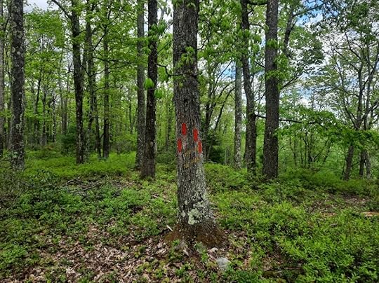
 This is Point A. The faded yellow blazed trail begins behind the markings on this tree and goes down to Big Flat Vista.
I reached Point A, where there is a faded, old yellow blazed side trail that goes down to Big Flat Vista. The yellow blazes are followable. This side trail is about 700 feet long. The view is from the top of a huge cliff and you can see the mountains on the other side, and even the dam. Be very careful as the view is at a point.
Back on the BP, the level trail continued. Watch for a left turn where a yellow side trail joins from the right. Reach a logged area and hike around it. Descend steeply into a gorge with cascades and streams. This gorge is beautiful. Cross the creek with cascades above and below the trail. Continue down with views of the creek far below with waterfalls. Reach Gravelly Run, a sublime creekside hike with more boulders, cascades, and pools. Pass some cabins and reach the end of Lick Island Road where there is a trailhead; it feels like the most isolated trailhead in the state.
Cross Gravelly Run and continue up Lick Island Run on an old grade. This gorge is beautiful with open forests, rushing creeks, and wildflowers. There is also good potential camping but I saw no established sites. At one spot, you can see a spring gushing from the slope across Lick Island Run, creating a waterfall. Pass a cascade and then the BP turns left where the two branches of Lick Island Run meet.
The next section is a highlight of this loop. Wow. So beautiful. The trail and gorge steepens and you can see nonstop cascades below the trail. Look for Lick Island Falls, it is below the trail among a cluster of large boulders. The falls are beautiful, maybe 20 feet tall. The boulders have a cave and overhang. (Downstream from Lick Island Falls, the creek cascades under the overhang of a giant boulder, like it’s flowing through a cave). Hike along the side of the gorge and enjoy the waterworks below. Truly beautiful. Cross the creek and see more small waterfalls. Cross it again and enter a stunning pine forest. It was like a cathedral. An absolute joy. Leave the sublime pine forest and enter fern glades; the scenery does not stop. Pass some cabins and follow a road to Ridge Road.
Continue on the BP with more glades and open forests. Climb up meadows of spruce and pine with fine views. It’s like a small slice of Dolly Sods. Reach an obvious 4 way intersection with an old quarry. If you want to see the Meadow of the Stars, follow the forest road to the left for a few hundred feet to a beautiful mountaintop meadow with a view. I was lucky enough to camp here when it was filled with yellow flowers, an experience I won’t forget. It’s a dry campsite, so bring enough water. The views of the stars and Milky Way are incredible. This meadow is a nice feature that most people miss.
Back on the BP, enjoy more glades and forests. Reach Ridge Road. I decided to follow the road to see the vistas, but the BP section is also very nice. The BP climbs to the firetower and cabin, and descends to scenic Brooks Run with camping and water. The BP then crosses Ridge Road. Do not continue on the BP; follow Ridge Road to a gated forest road on the right with a sign for the Joe King Trail. (I continued north on Ridge Road for a few hundred feet to Norcross Vista, but you might want to skip that. It is a great view).
Now follow yellow blazed Joe King Trail; it was a pleasant surprise. It was well blazed and followed a nice forest road that would have non-stop views when the trees are bare. Reach a clearing and follow the trail. The terrain was hilly. It did get a bit brushy in places, but it was well blazed and there was a treadway. You will pass a big hemlock, just after that look to your left. Just off the trail is Joe King Vista, a superb view of the mountains and valleys to the north. A beautiful spot. The trail leaves the laurel and crosses lime green fern glades. Wow.
And then you reach Phins Trail.
I hiked Phins Trail. It did not like me. It won’t like you. It is basically a bushwhack through thick laurel with sparse blazes. At one point, I lost the trail and ended up exploring a cool boulder city which was a nice consolation prize. As I hiked east, the trail was in better shape and followed a very neat, narrow ridge with a small view. It then descended steeply around rock outcrops. Then the next problem arrived-the trail followed narrow, worn out switchbacks across the steep slopes. The slick leaves made it slow going and a bit treacherous. While Phins Trail would be the ideal route, it is best to skip until it gets maintenance.
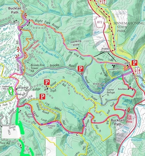
The blue highlighted routes on the map may be good alternatives. I did not hike those trails. Brooks Run Road is actually quite scenic and passes Brooks Run Falls.
Overall, this loop was superb. It has so much diversity and scenic highlights. There was little man-made noise. It had it all-views and waterfalls, giant rocks and creeks. I loved all the fern glades and diverse forests. Parts of the loop explore serene highlands with birdsong, other parts are lower with the non-stop sound of creeks and cascades. These trails need more hikers, so get out there. I will surely be back.
 Purple highlight is my route; blue highlight are possible alternative routes to bypass Phins Trail. I did not hike the trails on the blue highlight route. The trails are not marked blue or purple on the ground. C is camping or potential camping. Blue dots are cascades and falls. Locations are approximate. Basemap from Bureau of Forestry.
View this post on InstagramA post shared by Jeff Mitchell-Outdoors Author (@hiking_mitch)
View this post on InstagramA post shared by Jeff Mitchell-Outdoors Author (@hiking_mitch)
View this post on InstagramA post shared by Jeff Mitchell-Outdoors Author (@hiking_mitch)
View this post on InstagramA post shared by Jeff Mitchell-Outdoors Author (@hiking_mitch)
View this post on InstagramA post shared by Jeff Mitchell-Outdoors Author (@hiking_mitch)
View this post on InstagramA post shared by Jeff Mitchell-Outdoors Author (@hiking_mitch)
Jeff Mitchell's Blog
- Jeff Mitchell's profile
- 3 followers


